Avalanche bulletin
Avalanche conditions
Snow is settling in most places but a persistent slab could still be present in the Eastfjords and Tröllaskagi. Chances of wet sluffs duirng warm weather.
Written by a specialist at 25 Apr 14:29 GMT
Avalanche bulletins for selected areas 
The avalanche bulletin is at a regional scale. It does not necessarily represent avalanche danger in urban areas.
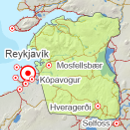
Southwest corner
-
Sat Apr 26

Low danger -
Sun Apr 27
Low danger -
Mon Apr 28
Low danger
Forecast made: 25 Apr 10:09 GMT. Valid until: 26 Apr 19:00 GMT.
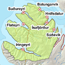
Northern Westfjords
-
Sat Apr 26
Low danger -
Sun Apr 27
Low danger -
Mon Apr 28
Low danger
Forecast made: 25 Apr 14:18 GMT. Valid until: 26 Apr 19:00 GMT.
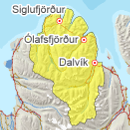
Tröllaskagi
-
Sat Apr 26

Moderate danger -
Sun Apr 27
Low danger -
Mon Apr 28
Low danger
Forecast made: 25 Apr 14:44 GMT. Valid until: 26 Apr 19:00 GMT.
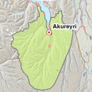
Eyjafjörður (experimental)
-
Sat Apr 26
Low danger -
Sun Apr 27
Low danger -
Mon Apr 28
Low danger
Forecast made: 25 Apr 16:16 GMT. Valid until: 26 Apr 19:00 GMT.
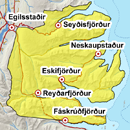
Eastfjords
-
Sat Apr 26
Moderate danger -
Sun Apr 27
Moderate danger -
Mon Apr 28
Moderate danger
Forecast made: 25 Apr 14:14 GMT. Valid until: 26 Apr 19:00 GMT.
Weather forecast in terms of avalanche danger
Some precipitation in most parts of the country over the weekend. Widely partly cloudy and warm during the day.
Written by a specialist at 25 Apr 14:48 GMT