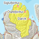
Avalanche bulletin - Tröllaskagi 
-
Sat Apr 26

Moderate danger -
Sun Apr 27

Low danger -
Mon Apr 28
Low danger
Snow has subsided during freeze-thaw and sunny weather during the last week. The snow pack is generally considered stable although wet avalanches may release during warming on solar aspects.
Avalanche problems in the area
-
Type
-
HeightAll heights
-
Aspect
-
Probability
-
Size
Wet avalanches may release during warm and sunny weather over the weekend.
Snow layers and snow cover
Snow has subsided during freeze-thaw and sunny weather in the last week and is generally considered stable. More layering is expected in upper parts where warming has had less effect. Warming and freeze-thaw will continue strengthening the snowpack in the next days although wet avalanches can be expected on solar aspects.
Recent avalanches
Small skier triggered slab in Skíðadalur, April 21st. Several small, wet loose avalanches and roller balls have been observed across the region this week.
Weather forecast
Calm weather, sunny with overnight freezing this weekend. Up to 13°C in the lowlands.