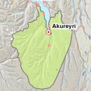
Avalanche bulletin - Eyjafjörður (experimental)

  • Thu Nov 21

    Moderate danger
  • Fri Nov 22

    Moderate danger
  • Sat Nov 23

    Moderate danger

Since Friday 15.11., snow has added and drifted in northerly winds and accumulated in sheltered areas. However, there is still not much snow in avalanche release areas. With time, weaknesses may form in the snowpack due to continued N-snowfall and cold temperatures.

The avalanche bulletin is at a regional scale. It does not necessarily represent avalanche danger in urban areas.

Avalanche problems in the area

Snow layers and snow cover

Since Friday 15.11. snow showers and snowdrift in northerly wind have caused snow to accumulate in gullies and other sheltered areas. The ground was mostly bare before Friday, with some old snowdrifts at high elevations. There is still not much snow in mountains but small wind slabs are possible. Light snow showers and cold temperatures are forecasted over the next few days. Weak layers with facets may form over time, due to cold temperatures.

Recent avalanches

No reports of recent avalanches.

Weather forecast

Light snow showers and calm variable wind on Thursday. A little more snowfall on Friday with NE wind and snowdrift. Continuing cold temperatures.

Forecast made: 20 Nov 15:16 GMT. Valid until: 22 Nov 19:00 GMT.

Avalanche Danger Scale

Very high
High
Considerable
Moderate
Low

More

About the bulletin

IMO issues an avalanche bulletin Monday, Wedenesday and Friday at 16:00 GMT for three selected areas.

Safe backcountry travel requires training and experience. You control your own risk by choosing where, when and how you travel.

More


Other related web sites


This website is built with Eplica CMS