The situation at Askja remains unchanged
Three volcanic systems were discussed at yesterday's long-term monitoring meeting at IMO. The eruption in Litli-Hrútur has been declared over. Uplift has been detected in Torfajökull volcanic system
The latest deformation data indicates that the inflation continues at Askja with the position and depth of the inferred magma source unchanged since September 2021. The magma is accumulating at a depth of about 3 km, and there are currently no indications from geodetic observations that the magma has shallowed further. Recent deformation data show uplift in the middle of the Torfajökull caldera. The uplift began in June and a few centimeters have been measured which can be seen both in InSAR and GPS data. The most likely scenario is that magma is accumulating at depth.
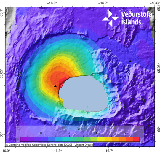
Figure caption: Satellite data (Insar image) that shows uplift in Askja for the period July 2021- August 2023. Yellow and red areas in the middle of the image are those experiencing the largest deformation.
It is important to follow the advice of rangers in the area
IMO specialists are taking measurements in Askja today and preliminary results can be expected on Thursday. They are measuring gas and temperature in lake Askja as well as in Víti and they are also taking samples to estimate the pH value of the lakes. These measurements are performed to identify possible changes in the level of activity of the volcano and are a part of a long-term monitoring plan for Askja.
Since the uplift began in September 2021, rangers, guides, and other people have been asked to follow carefully any updates on changes that may occur in the area. Travelers have been advised to pay close attention to the ranger's instructions, all of which are drawn up in consultation with the Icelandic Civil Protection and the Police in the Northeast. Travelers are advised against bathing in Víti and are recommended not to stay for a lprolonged time in the area. We emphasize that a level of uncertainty for Askja volcano, as declared by the Civil Protection, is still in force.
Significant increase in activity prior to the eruption in Askja in 1961
The last eruption in Askja, which began on 26 October 1961, was an effusive eruption, as most of the eruptions occurred at this volcano. Twenty days before, a significant increase in geothermal activity was observed and increased seismicity was reported in the area. New solfataras were observed in the area which had not been active before. The historic catalogue of earthquakes covering the period 6-26 October 1961 recorded six earthquakes above M3 and one of which was above M4.
A couple of days ago the IMO received a report about a possible short-lived steam explosion close to Bátshraun (east of Víti) which could indicate an increase in the geothermal activity. When footage of the plume were investigated, it was estimated that it was more likely dust carried by the wind. Small landslides and rockfalls are quite common in the area and are often followed by loud sounds which can be heard within the caldera. The last weeks have been very dry and there is lots of fine material in the area which can be carried by the wind very easily.
Upflift in Torfajökull volcanic zone
Recent deformation data show
uplift in the middle of the Torfajökull caldera. The uplift began in June and a
few centimeters have been measured which can be seen both in InSAR and GPS
data. The most likely scenario is that magma is accumulating at depth. In the
coming weeks, effort will be made to further analyze the data and run models to
constrain the depth and volume of intruded magma. No significant changes in
seismicity have occurred since the beginning of the uplift. The last eruption
in Torfajökull was in 1477. The volcanic system includes a central volcano and
a fissure swarm (direction NE-SW) and is about 40 km long and 30 km wide. At
the central volcano is a caldera which is 18x12 km, there is the largest
geothermal area of Iceland which is about 150 km2.
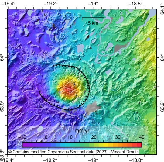
Figure caption: Satellite data (Insar image) that shows uplift in Torfajökull caldera. Yellow and red areas in the middle of the image are those experiencing the largest deformation
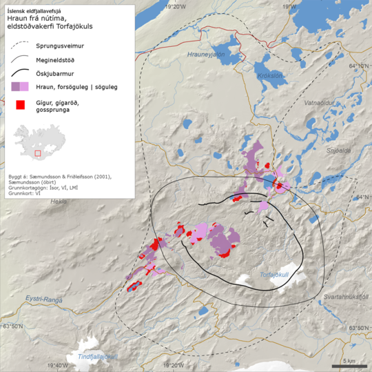
Figure caption: Map from the Catalogue of the Icelandic Volcanoes that shows the Torfajökull volcanic system.
The eruption at Litli-Hrútur declared over
Ten days have passed
since last activity was seen in the crater close to Litli-Hrútur and since
volcanic tremor reached its background level. No deformation is detected in the
area and the seismic activity has decreased significantly. It seems that yet
another chapter is closed in the volcanic activity on the Reykjanes peninsula.
It is very important to keep in mind that there are still hazards close to the
eruption site. The newly formed lava is still very hot. In some areas only a
thin shell has formed over the newly formed lava and beneath can be extremely
hot and unsolidified lava. The edges of the newly formed lava can be unstable
and large pieces of lava can fall. Gas escaping from the lava can collect in depressions.
Fissures can also be in the area due to the intense seismic activity that occurred
before the eruption.