Earthquakes continue to be recorded at great depths near Grjótárvatn
M3.2 earthquake recorded yesterday morning
Update 17. January 14:00 UTCNearly 100 earthquakes above M1.0 recorded in January
M3.2 earthquake recorded yesterday, the largest in the area since activity increased in August 2024
Magma intrusion at depth considered the most likely cause of seismic activity
No indications that magma is moving towards the surface
Seismic activity continues to increase near Grjótárvatn. So far in January, nearly 100 earthquakes above M1.0 have been recorded. This is comparable to the total number of earthquakes in December 2024, which was the highest monthly count ever recorded in the area.
Yesterday morning, on January 16, an M3.2 earthquake was detected. No reports have been received by the Icelandic Meteorological Office indicating that the earthquake was felt in inhabited areas, though residents in nearby regions may have noticed it. This was the largest earthquake recorded in the area since activity began increasing in August 2024; previously, an M3.1 earthquake was recorded on December 18, 2024.
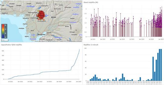
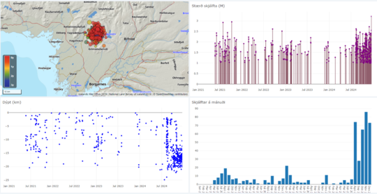
Composite image from the IMO's earthquake visualization tool, showing activity near Grjótárvatn from July 2021 to January 2025. The upper left map shows earthquake locations. The upper right graph displays earthquake magnitudes. The lower left graph shows the cumulative number of earthquakes, while the lower right graph illustrates the monthly earthquake count.
On January 2, a tremor episode lasting about an hour was recorded. Since then, one additional tremor episode occurred on January 10, also lasting just over an hour.
News about this activity was published on January 9 reviewing the activity, highlighting that the earthquakes exhibit an unusually high b-value. This is often associated with earthquakes in volcanic areas and indicates a relatively high proportion of small earthquakes. The most likely explanation for this seismic activity is believed to be magma intrusion at depth rather than tectonic movements. However, current monitoring data show no indications that magma is moving towards the surface.
The Icelandic Meteorological Office continues to monitor the activity closely and is working on a new monitoring plan for the area. This includes plans to increase the number of instruments to improve surveillance and gain a clearer understanding of the development and causes of the activity.
Update 9. January 12:30 UTC
A tremor episode on Thursday, January 2nd
Ongoing earthquake activity characterized by deep earthquakes
No signs of deformation from GNSS station
A deep magma intrusion is likely the cause of the earthquakes
No indication of magma getting shallower
Monitoring level in Ljósufjöll has been elevated
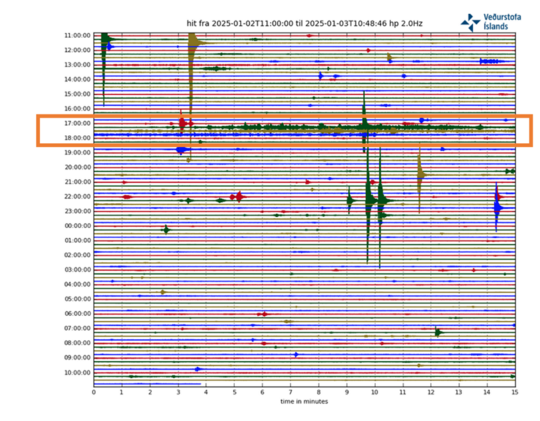
On Thursday, January 2nd, a tremor event was measured between 5:00 PM and 6:00 PM with its origin at Grjótárvatn. The tremor, lasting about 40 minutes, consisted of a series of continuous small earthquakes, most of which were too small to be located properly. Only two earthquakes within the tremor signal were located, they originated at a depth of approximately 15 km, with magnitudes of M1.5 and 1.8. A total of about 20 earthquakes were recorded that day, all at depths of 15–20 km and magnitudes ranging from M0.1–2.0.
Continuous tremor recorded at the new seismic station in Hítardalur between 5:00 PM and 6:00 PM on Thursday, January 2 (orange box). Individual earthquakes are visible before and after the tremor.
Earthquakes at these depths are unusual in Iceland. However, there are some examples, such as within the volcanic systems of Eyjafjallajökull in 1996, at Upptyppingar in 2007, as well as east of Bárðarbunga caldera where deep earthquakes are observed regularly.
In such volcanic settings, the mechanism causing the deep seismicity and associated micro earthquakes is the increased pressure in the crust due to magmatic intrusion. That causes sudden deformation which breaks the crust.
Yesterday morning (08.01), a monthly meeting was held at the IMO to
review recent activity in volcanic systems across the country. The increased
seismic activity near Grjótárvatn was reviewed and possible explanations
discussed. Additional analysis was recently performed on the seismic data for
the period 2021-2024 near Grjótárvatn. The
results show that this seismic activity is characterized by a high b-value
(~2), like what was observed in the deep seismic swarm at Upptyppingar in
2007–2008. High b-values are often associated with earthquakes in volcanic
regions, indicating an unusually high proportion of small earthquakes.
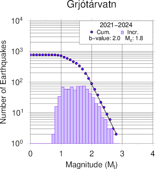
Gutenberg-Richter distribution illustrating the relationship between
earthquake magnitude and frequency at Grjótárvatn during 2021–2024. The slope
indicates a b-value of 2.
The analysis of satellite data from the period 2019 to summer 2024 does not show measurable deformation on the surface and InSAR observations are currently not usable in this area due to snow cover.
However, in early November last year, a GNSS station was installed in Hítardalur, approximately 4km NW of Grjótárvatn. Since then, no surface deformation has been measured, but this does not exclude the involvement of magma at depth. If magma is accumulating at deep levels (> 16 km), geodetic modelling indicates that deformation is not likely to be detected at the surface until the volume of intruded magma is quite large.
In addition to the depth of the earthquakes and their b-value, the duration of the activity along with the recent tremor pulses and the analogy with other volcanic systems indicate that the most likely explanation of this seismicity is a magmatic intrusion at depth. However, monitoring data currently available show no indications that magma is moving toward the surface.
As long as the seismic activity continues at similar depths, more earthquakes of around magnitude 3 can be expected, but it is unlikely that earthquakes much larger than magnitude 4 will occur at this depth.
Considering the increased level of activity and a likely deep magma
intrusion, the Icelandic Meteorological Office (IMO) has raised the monitoring
level for Ljósufjöll and work is underway to develop an enhanced monitoring
plan for the area.
- The M3,2 earthquake on the evening of December 18 is the largest so far
- No ground deformation has been detected on GNSS observations
- No indication that magma is moving within the upper crust
- Small fissure eruptions are characteristic of volcanic activity within Ljósufjöll volcanic system
An earthquake with magnitude M3.2 was detected near Grjótárvatn on the evening of December 18. The IMO received reports that the earthquake had been felt around Borgarfjörður and Akranes. Seismic activity has been measured around Grjótarvatn regularly since spring 2021, but in recent months it has been increasing, as shown in the figure below. The earthquake detected on December 18 is the largest since the autumn of 2021 when two earthquakes of magnitude M3 occurred. Prior to this, significant seismic activity was last detected there in 1992, when two earthquakes of magnitude M3 occurred, one larger than M3.2, and several others above M2.0. The earthquake catalogue which we are referring to here goes back to 1991 (SIL-system).
Screenshot from the Skjálfta-Lísa system.
The IMO has increased the monitoring of the area with new installations of equipment in Hítardalur both a seismometer (at the end of September) and a GNSS station (at the beginning of November). The new seismometer has improved the monitoring system's ability to detect small earthquakes. Indeed, before it was installed, few earthquakes below M1.0 were detected because the nearest seismometer was relatively far away, at about 30 km from the active area. However, the increased level of seismicity is not an artifact of a more sensitive monitoring network. If we consider only those earthquakes above M1.0, it is evident that seismic activity in the area was increasing before the installation of the new station.
After the seismic station was installed closer to the active area, the earthquake location improved significantly. The depth of the majority of the earthquakes in the area is now well constrained to be at a depth between 15-20 km. Since the GNSS station was installed in Hítardalur, the data does not show any detectable deformation at the surface. Analysis of satellite data (InSAR) from the period 2019 to summer 2024 also shows no evidence of surface deformation.
Yesterday morning (19 December) the regular scientific meeting to assess the situation in the Reykjanes peninsula took place. Specialists from the IMO and the Earth Sciences department at the University of Iceland took the opportunity to also discuss the newest data and ongoing activity at Grjótarvatn.
It is currently not possible to determine the cause of the ongoing seismic activity, but two possibilities are considered: magma accumulation at depth or intra-plate tectonic movements.
More analysis is needed to assess with certainty which process is responsible for the ongoing activity at Grjótarvatn. However, the current monitoring data indicates that there is no evidence of magma migrating to shallow depths. The IMO will plan the deployment of additional stations (seismic and GNSS) to better constrain the ongoing phenomena and monitor its evolution.
In the event that magma starts propagating towards the surface, it is most likely that larger precursors will be detected, such as a rapid increase in seismic activity (in terms of number and magnitude of earthquakes), a migration in their depth and/or ground deformation.
Eruptive history
Grjótarvatn is within the volcanic system of Ljósufjöll in the Snæfellsnes Volcanic Zone. The last eruption of Ljósufjöll was a small effusive eruption which occurred in the 10th century CE and produced the Rauðhálsahraun lava field, of about 13 km2 (at about 15 km northwest from Grjótarvatn). On average, during the last 10,000 years, this volcanic system has erupted every 400 years. In the event of an eruption here, the most likely scenario is a small effusive eruption (< 0.1 km3), or mildly explosive, with lava fountaining and lava flows. If an eruption occurred, a small area would be expected to be affected by the main associated volcanic hazards which are: lava flows, gas pollution and very localized tephra fallout. More information on Ljósufjöll volcanicsystem is available here.
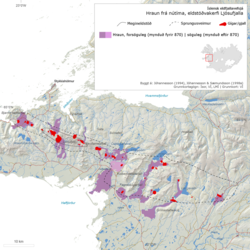
Ljósufjöll volcanic system, Holocene lava flows and scoria deposits.
