On the weather forecast and the flood conditions
Travellers urged to avoid all watercourses in certain regions in the coming days
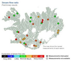
Rainfall-induced flooding is occurring on Barðaströnd, Snæfellsness, and at the Mýrdalsjökull ice-cap. Additionally, streams close to the capital region have risen sharply.
Hvítá, Ölfusá, Sog
The level of Hvítá and Ölfusá has not increased significantly yet, although further intense rainfall is expected in the region until late on Thursday. The discharge of Sog, which drains from Þingvallavatn, is presently 220 m³/s, which is twice the river's typical level. Flooding in Sog will most likely peak on Thursday afternoon, following additional input from overnight rainfall.
Múlakvísl, Jökulsá á Sólheimasandi, Krossá in Þórsmörk
The discharge of glacial rivers Múlakvísl and Jökulsá á Sólheimsandi is high due to sustained rainfall. Both rivers are at levels seen only during outburst floods in recent decades. Glacial river Krossá in Þórsmörk is exceptionally high, resulting in widespread inundation of the valley. Note that river levels around Mýrdalsjökull will increase further overnight and on Thursday.
Rivers east of Mýrdalsjökull
Rivers to the east of Mýrdalsjökull are beginning to rise rapidly as rainfall intensifies in the region. Flood conditions are expected in streams and rivers from Mýrdalsjökull to Hornafjörður. Djúpá, located west of Skeiðarársandur, has reached a discharge of 100 m³/s and the river will swell markedly overnight and on Thursday.
Caution
Such prolonged, intense rainfall is extreme, even by Icelandic standards. Localised flooding is likely and small streams on hiking routes will become impassable. Travellers are urged to avoid all watercourses in the above-mentioned regions in the coming days. Most rivers will take days to return to pre-flood conditions, so keep this in mind when making travel plans.


