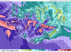
Warning - strong or severe gale
Forecast for Tuesday 10 March
Icelandic Meteorological Office wishes to emphasize the following weather forecast:
Warning
A strong gale or severe gale warning (average wind velocity 20 to 28 m/s) is in effect for all parts of Iceland after noon tomorrow.
Forecast for tomorrow, 10 March 2015:
Increasing southeast winds, 18-28 m/s after noon with violent wind gusts by mountains in the South and West part of Iceland. Increasing wind in the north and east early tomorrow evening. Snow at first, but later sleet and possibly rain in the lower elevations. Considerable precipitation in the south and southeast, and temperatures warming above freezing for a short while. Less precipitation in the North and East. Winds turn southerly with snow showers in the West tomorrow evening, with decreasing temperatures.
Forecaster's remarks
Bad weather is expected from noon tomorrow until late tomorrow evening and night. Visibility will be greatly diminished due to snow and blowing snow and travelling across mountain roads will be challenging, perhaps impossible. The weather will pass in the southwest between 19 and 21 UTC, but after midnight in the North and East.
Elín Björk Jónasdóttir
Þorsteinn V. Jónsson


