Eruption at the Sundhnúkur crater row remains likely
Magma volume beneath Svartsengi is at its highest since the eruption series began in December 2023
Updated 25 March at 15:00 UTC- Magma accumulation continues, but the rate of uplift has slowed in recent weeks
- The most likely scenario is that this period of magma buildup will end with a magma intrusion and/or an eruption, likely emerging first in the area between Sundhnúkur and Stóra-Skógfell
- Seismic activity has gradually increased in recent weeks, indicating that pressure at the eruption site is increasing
- An eruption could begin with very little warning
- The hazard assessment remains unchanged
GPS deformation data shows that magma continues to accumulate beneath Svartsengi, although the pace of land uplift has slightly decreased in recent weeks. Despite the slower uplift, experts still consider it likely that a magma intrusion and/or eruption will occur along the Sundhnúkur crater row.
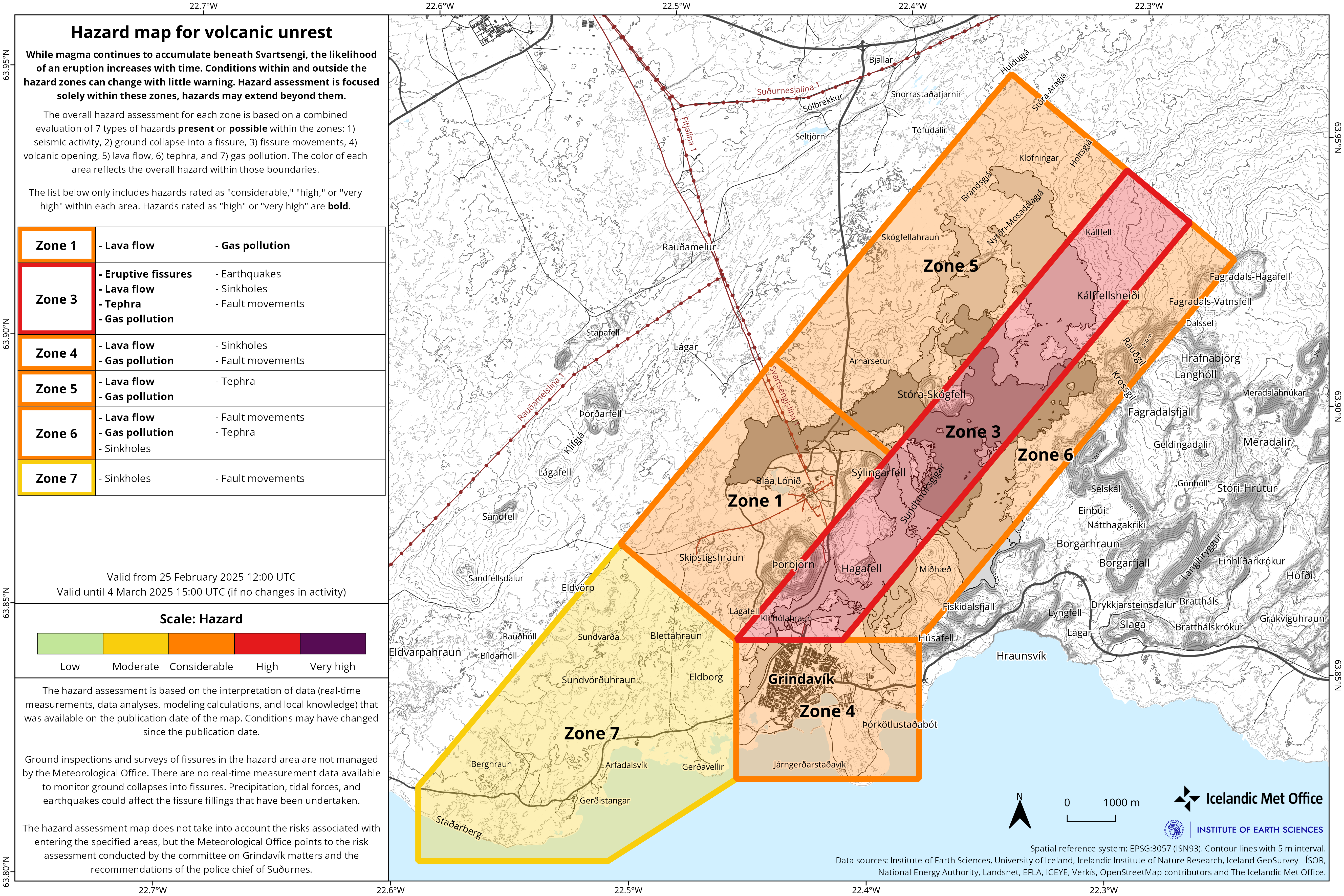
The potential size of the eruption depends on how much magma is released from the magma chamber when the eruption begins. The volume of magma has never been greater since the eruption sequence at the Sundhnúkur crater row began in December 2023, meaning the next eruption could be larger than previous ones in terms of volume. It is most likely that magma will first surface in the area between Sundhnúkur and Stóra-Skógfell, a pattern seen in six of the seven eruptions since volcanic activity resumed in late 2023. The exception was the eruption in January 2024, when magma first emerged just south of Hagafell.
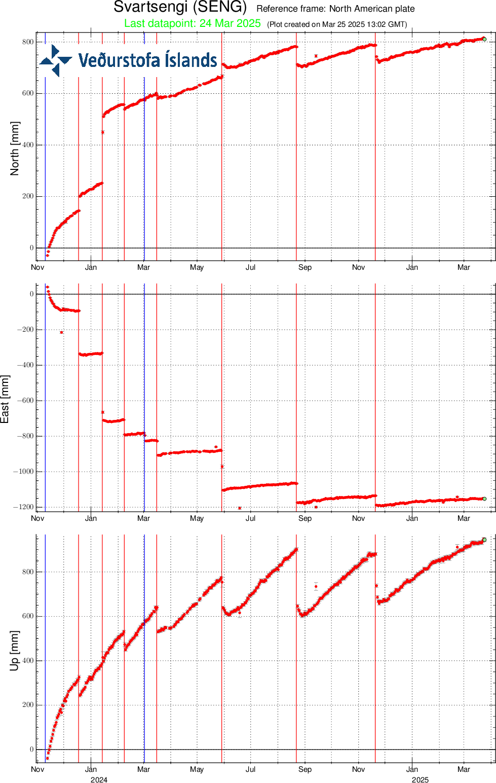
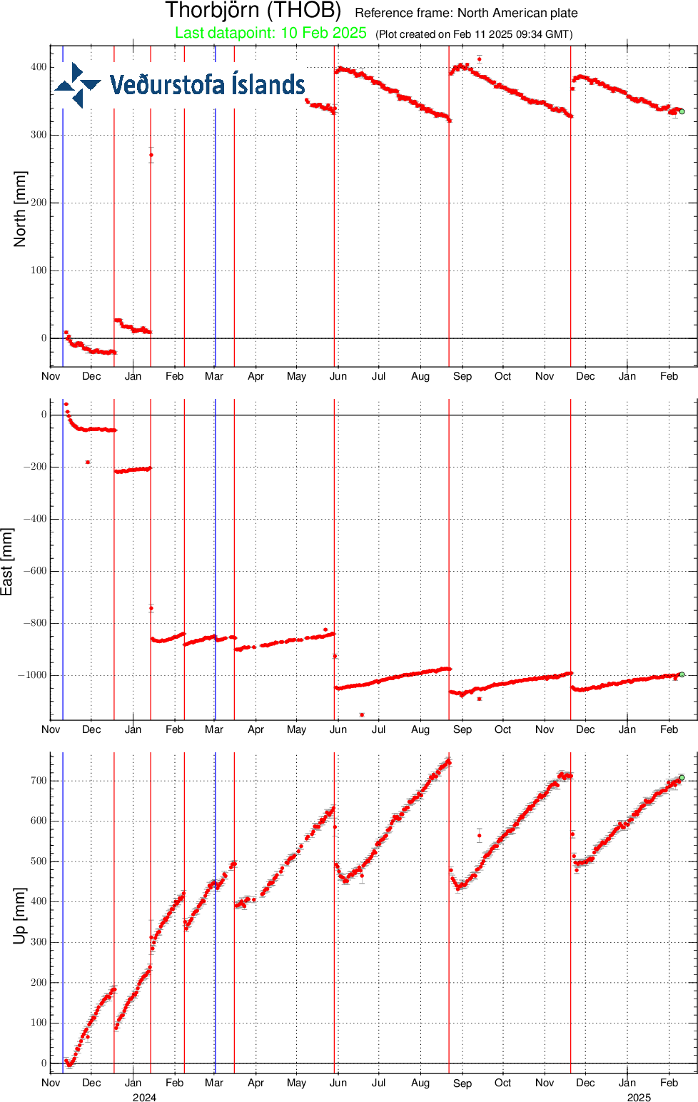
GPS displacement measurements from the SENG station in the Svartsengi area (since November 11, 2023) show movements in the north, east, and vertical directions (top, middle, and bottom panels, respectively). The bottom panel shows vertical uplift in millimeters, with the most recent measurement (March 24) marked by a green dot. The red vertical lines indicate the start dates of the last seven eruptions (December 18, 2023; January 14; February 8; March 16; May 29; August 22; and November 20, 2024). Blue lines show the timing of magma intrusions that did not result in eruptions (November 10, 2023, and March 2, 2024).
Seismic activity has been slowly increasing in recent weeks. Repeated events along the Sundhnúkur crater row, where magma intrusions and eruptive fissures have formed, have reduced stress in the crust over time. As a result, fewer and smaller earthquakes are detected in the lead-up to eruptions, compared to earlier in the eruption sequence. Warning time before an eruption is expected to remain very short; in the last two eruptions, only 30–40 minutes passed from the first signs of increased seismicity to the actual onset of eruption. Indicators that magma is moving toward the surface include intense earthquake swarms on the Sundhnúkur crater row, pressure changes in HS Orka's boreholes at Svartsengi, deformation observed in fiber-optic cables, and surface changes captured by real-time GPS measurements.
The hazard assessment remains unchanged and is valid through April 1, unless conditions change. See also what to expect in the next eruption at the same link.

Updated 18 March at 13:00 UTC
Magma continues to accumulate, and its volume beneath Svartsengi has never been greater since the eruption sequence began in December 2023
The most likely scenario is that this magma accumulation phase will end with a magma intrusion and an eruption, initially occurring in the area between Sundhnúkur and Stóra-Skógfell
Seismic activity has been gradually increasing over the past few weeks, indicating that pressure at the eruption site is rising
An eruption could begin with very little warning
The hazard assessment remains unchanged and is valid until March 25
There has been a clear increase in seismic activity near the Sundhnúkur crater row on a weekly basis, except for the last week of February, which was likely due to weather conditions. The seismic station that previously caused measurement disturbances has been corrected. Earthquake activity continues in the same location as in the lead-up to previous eruptions—between Sundhnúkur and Stóra-Skógfell—where magma first reached the surface in six of the seven eruptions since December 2023.
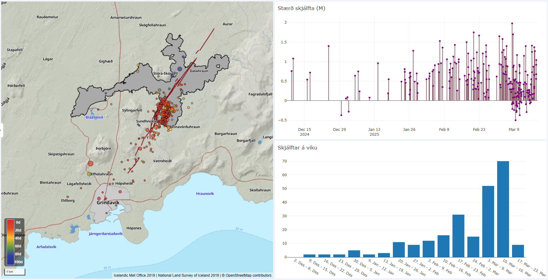
The image shows earthquake activity around the
Sundhnúkur crater row from the last eruption on December 8, 2024, until today,
March 18. The map displays the location of earthquakes during this period. Note
that the positioning of earthquakes east of the Sundhnúkur crater row still
needs to be corrected. The lava field from the last eruption is shown in gray,
while dark red lines indicate the location of eruption fissures from eruptions
since December 2023. The upper graph shows earthquake magnitudes over time,
while the lower graph illustrates the weekly earthquake count, which has been
increasing recently.
Deformation measurements indicate continued uplift
Deformation measurements (GPS measurements) indicate that uplift continues, although at a slightly reduced rate. There are no signs of subsidence in the area around Svartsengi, according to GPS data and InSAR observations. Magma continues to accumulate beneath Svartsengi, and its volume has never been greater since the eruption sequence at the Sundhnúkur crater row began in December 2023.
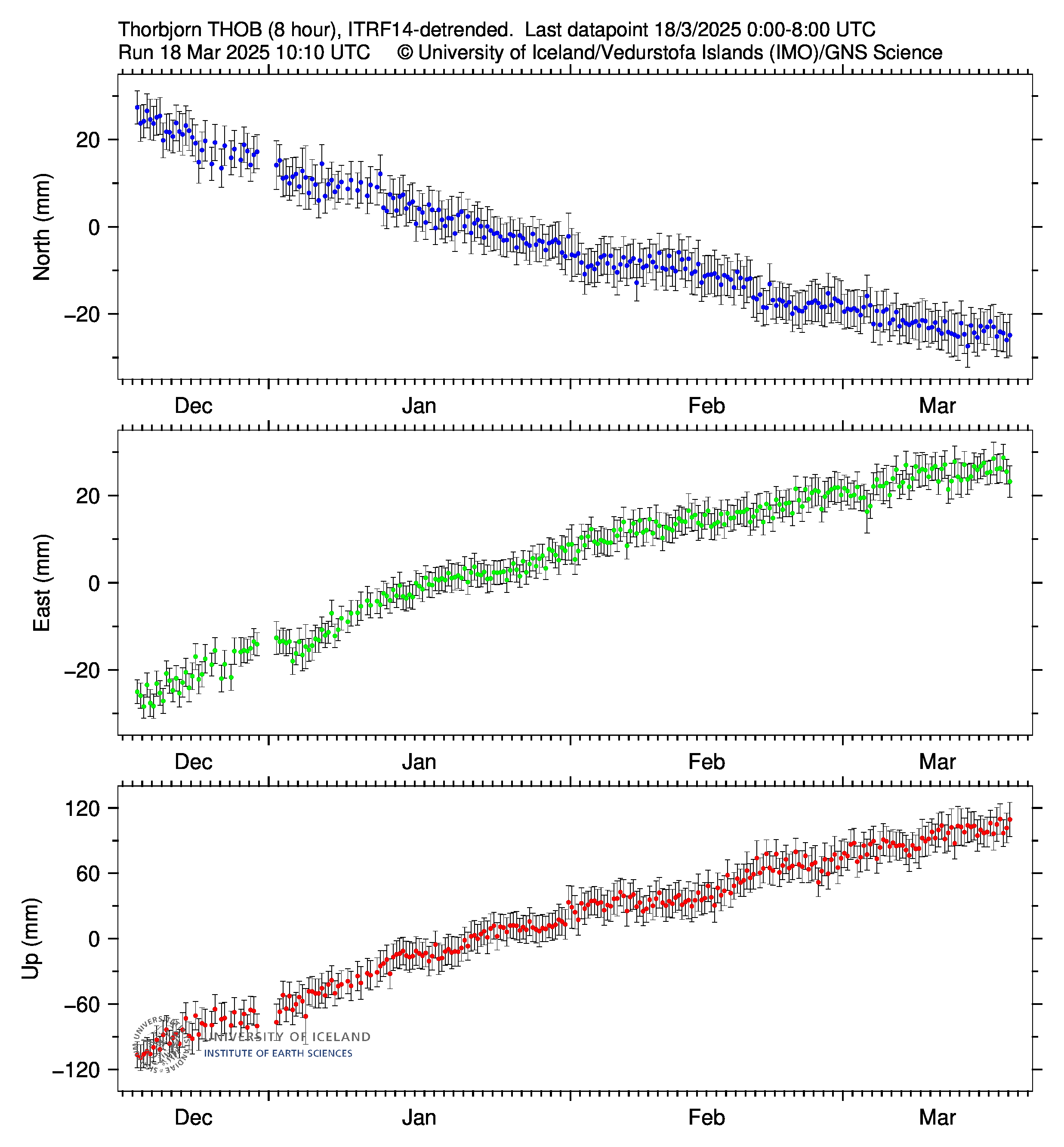
The graph shows 8-hour solutions for the GPS
station THOB, located at Þorbjörn. The data represent movements in the north,
east, and vertical directions (top, middle, bottom).
The hazard assessment has been updated but remains unchanged and is valid until March 25, unless conditions change.

Updated 17 March at 17:30 UTC
Magma continues to accumulate, and its volume beneath Svartsengi has never been greater since the eruption sequence began in December 2023
The most likely scenario is that this magma accumulation phase will end with a magma intrusion and an eruption, which would first propagate in the area between Sundhnúkur and Stóra-Skógfell
Seismic activity has increased in recent days, indicating that pressure at the eruption site is rising
An eruption could begin with very little warning
The hazard assessment remains unchanged and is valid until March 18
No change has been observed in the location of seismic activity at the Sundhnúkur crater row compared to the lead-up to previous eruptions
On March 11, the Icelandic Meteorological Office reported changes in the location of earthquakes over the past few weeks, with seismic activity appearing to be positioned several hundred meters further east than in the lead-up to previous events. Initially, these earthquakes were thought to be triggered by increased pressure from magma accumulation beneath Svartsengi.
Meteorological Office experts have since conducted a high-resolution analysis of earthquake locations. Earthquake locations are determined using signals from multiple seismometers in a given area, meaning that interference from a single instrument can affect the final location calculations. The influence of each seismic station in the region on the earthquake positioning results was analyzed, revealing an issue with one instrument that caused the seismic activity to appear farther east than before.
Further fault analysis and corrections are underway. As of Friday, March 14, earthquake review procedures have been temporarily adjusted by excluding data from the instrument responsible for the miscalculation.
Seismic activity is therefore still occurring in the same area as before the previous eruptions—between Sundhnúkur and Stóra-Skógfell—where magma first reached the surface in six of the seven eruptions since December 2023.
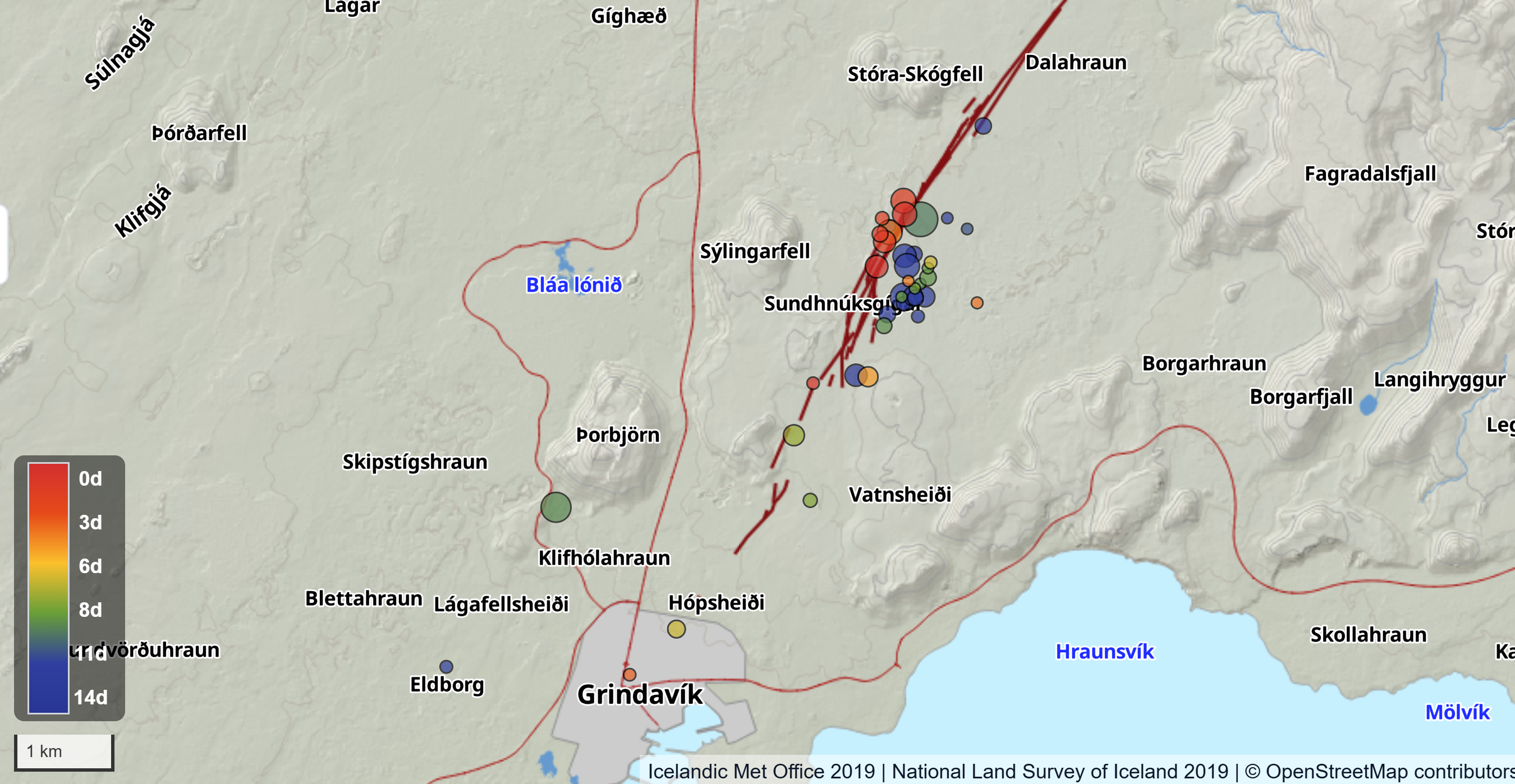
The map shows the location of earthquakes around the Sundhnúkur
crater row over the past 14 days. Red circles indicate the locations of
earthquakes recorded in the last three days, following the temporary adjustment
of data processing due to interference. These earthquakes are positioned on or
very near eruption fissures that have opened since December 2023, represented
by dark red lines. Other colors indicate the locations of earthquakes before
the data processing adjustment.
Updated 11 March at 16:20 UTC
- Magma accumulation continues at a similar rate.
- The volume of magma beneath Svartsengi is at its highest level since the series of eruptions began in December 2023.
- Seismic activity has increased in recent days.
- The most probable outcome is that this period of magma accumulation will culminate in a dike intrusion and eruption.
- An eruption could begin with very little warning.
- The hazard assessment remains unchanged and is valid until March 18.
Deformation measurements show that land uplift continues at the same rate as in recent weeks. Magma continues to accumulate beneath Svartsengi, and its volume has reached the highest level recorded since the eruptive series began at the Sundhnúkur crater row in December 2023.
Seismic activity in the Sundhnúkur crater row has been gradually increasing alongside magma accumulation, following a pattern similar to that observed before the November eruption.
Since the last eruption ended, seismic activity has been located slightly further east compared to the activity leading up to the eruption that began on November 20, 2024. The earthquakes east of the Sundhnúkur crater row are likely tectonic earthquakes caused by increased pressure in the region due to magma accumulation. Therefore, these earthquakes are not necessarily an indication of the likely eruption site, although this cannot be ruled out. Further analysis of the seismic data is currently underway and may shed more light on the cause of this shift in the earthquake location.
Considering the increasing seismic activity alongside continued land uplift and magma accumulation, the most likely scenario is that this period of magma accumulation will result in a dike intrusion towards the Sundhnúkur crater row. It is likely that this will result in a volcanic eruption, marking the eighth eruption since the end of 2023.
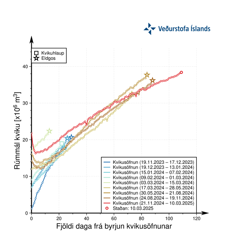
Graph showing the estimated volume of magma that has accumulated beneath Svartsengi between the eruptions and dike intrusions since November 2023
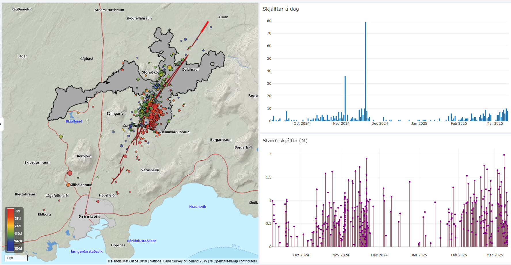
Image displaying seismic activity around the Sundhnúkur crater row from September 8, 2024, to today, March 11, 2025. The data therefore includes seismic activity between the eruption that ended on September 8 and the one that began on November 20, as well as the period from the end of the last eruption to today. Green circles on the map indicate the location of earthquakes before the eruption that began on November 20, 2024, while red circles represent earthquakes in recent weeks. The extent of the lava field created in the last eruption is depicted by the gray overlay, and dark red lines indicate the location of eruptive fissures that opened during the eruptions that occurred in the area since December 2023.
The next eruption could be larger than previous ones
Three months have passed since the most recent eruption concluded, lasting 18 days and ending on December 8. This is the longest period of magma accumulation that has been observed during this eruptive series on the Sundhnúkur crater row, with today marking 111 days since the last eruption began on November 20, 2024.
The volume of magma that has accumulated beneath Svartsengi during this period is the highest estimated since the beginning of this eruptive series in December 2023. Therefore, it is possible that, if an eruption occurs in the coming days or weeks, it could be comparable to or larger than the eruption in August 2024, which was the largest so far in terms of volume. Based on past events, the size of the possible eruption will depend on how much magma is released from the magma chamber when the eruption begins. Currently, it is difficult to predict the size of the next event with certainty.
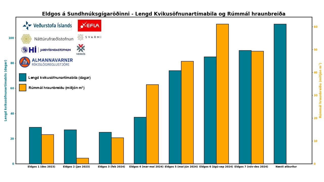
Graph showing the duration of magma accumulation periods (blue bars) leading up to eruptions in the Sundhnúkur crater row since December 2023, and the volume of the lava fields (orange bars) that formed during those eruptions. The blue bars indicate that the time between eruptions has been increasing since March 2024. The volume of the eruptions also increased until August 2024, but before the eruption in November 2024, the volume of magma beneath Svartsengi had not reached its previous levels before an eruption, as it has done today (see figure above). A large portion of the magma that exited the magma chamber beneath Svartsengi in January 2024 went into forming a magma dike, which is why the lava flow formed during that eruption was the smallest.
The hazard assessment remains unchanged and is valid until March 18, unless the situation changes. Use the same link to follow guidelines about what to expect in the next eruption.

Updated 4 March at 15:45 UTC
Land uplift continues at a similar rate
Recent weather conditions have likely affected the sensitivity of the detection network and limited seismic activity has been recorded in recent days
It is anticipated that an eruption may start with very short warning
The most likely scenario is a fissure opening in the area between Sundhnúkur and Stóra-Skógafell
- The area impacted by a volcanic eruption is determined by whether the eruptive fissures extend towards north or south
The hazard assessment remains unchanged and is valid until March 11
Deformation measurements indicate that land uplift continues at a similar rate as in recent weeks. The amount of magma beneath Svartsengi is now greater than what was estimated before the eruption that began on November 20. The likelihood of magma intrusion and an eruption is increasing, and all indications suggest that this could happen within the coming days or weeks.
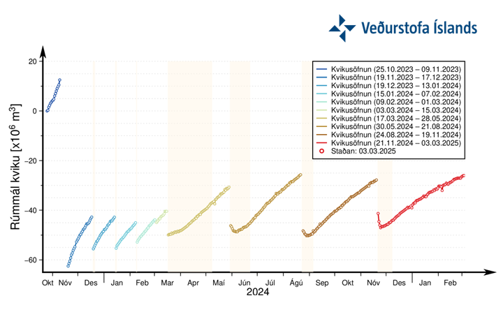
A graph showing the development of magma accumulation and the estimated total volume of magma in the accumulation zone beneath Svartsengi. The zero point is based on the state before land uplift began in late October 2023. The total volume of magma beneath Svartsengi is now greater than what had accumulated before the eruption on November 20.
Based on previous events on the Sundhnúkur crater row, the likelihood of a new event occurring within the next few days or weeks is increasing. It is most likely that magma would first surface in the area between Sundhnúkur and Stóra-Skógfell. This has been the case in six out of the seven eruptions that have taken place since volcanic activity began in late 2023. The exception was the eruption in January 2024 when magma first surfaced just south of Hagafell.
The impact of an eruption between Sundhnúkur and Stóra-Skógfell will depend on whether the eruptive fissure extends northward or southward.
Seismic activity around Sundhnúkur has slightly decreased in recent days compared to previous weeks. However, recent bad weather may have affected the measurement system's sensitivity, limiting the detection of smaller earthquakes. Due to repeated events along the Sundhnúkur crater row, where magma intrusions and eruptive fissures have formed, stress in the crust has been reduced with each event. This means that fewer and smaller earthquakes are recorded in the days and weeks leading up to an eruption compared to the early eruptions.
Eruptions are expected to occur with very limited warning time. In the last two eruptions, only about 30–40 minutes passed from the first signs of seismic activity to the onset of an eruption. The key signs observed when magma is moving toward the surface include intense small earthquake swarms along the Sundhnúkur crater row, pressure changes in HS Orka boreholes in Svartsengi, deformation detected in the fiber-optic cable, and surface deformation observed through real-time GPS measurements.
Hazard assessment unchanged
The hazard assessment remains unchanged and is valid until March 11, unless circumstances change. The Icelandic Meteorological Office's 24/7 monitoring team continues to closely observe the situation.

Updated 25. February at 14:40 UTC
Land uplift continues, but has slowed slightly in recent weeks
- The volume of magma accumulated beneath Svartsengi has exceeded the amount present before the eruption that began on November 20
It is anticipated that an eruption may start with very short warning
The most likely scenario is a fissure opening in the area between Sundhnúkur and Stóra-Skógafell
- The area impacted by a volcanic eruption is determined by whether the eruptive fissures extend towards north or south
Seismic activity is gradually increasing
The hazard assessment remains unchanged and is valid until March 4
Deformation measurements indicate continued land uplift, although it has slowed slightly in recent weeks. Updated model calculations suggest that magma accumulation has exceeded the amount that was present before the eruption that began on November 20. The likelihood of the next event occurring within the coming days or weeks remains elevated.
Seismic activity in the area has been gradually increasing since January.
The hazard assessment has been updated with no changes and remains in effect until March 4, barring any changes in the situation.
Updated 21. February at 14:15 UTC
- Updated models show that the amount of magma under Svartsengi has reached the same volume as had accumulated prior to the last eruption
- It is anticipated that an eruption may start with very short warning
- The most likely scenario is a fissure opening in the area between Sundhnúkur and Stóra-Skógafell
- The area impacted by a volcanic eruption is determined by whether the eruptive fissures extend towards north or south.
- The hazard assessment has been updated and the hazard level has been raised in three regions
Updated models show that the amount of magma under Svartsengi has reached the same volume as had accumulated prior to the previous eruption that began on November 20, 2024.
Based on previous eruptive events in the Sundhnúkur crater row, it is therefore assumed that there is an increasing probability that the next event will occur within a few days or weeks.
If an eruption occurs, it will be the eighth one in this area since December 2023. Stress in the crust has diminished with each dyke intrusion and eruption that has occurred. This means that fewer and smaller earthquakes may occur in the weeks and days before an eruption now as compared with when the activity first started.
A shorter notice is can thus be anticipated before the next potential eruption, and the warning might be as short as half an hour, depending on where the magma reaches the surface. The signals that have been seen when magma starts to move towards the surface are: a cluster of small earthquakes on the Sundhnúkur crater row, changes in the pressure in boreholes from the Svartsengi power plant and changes in the crust´s deformation seen by a fiber optic cable and the real-time GPS data.
Series of earthquakes occurred in the Sundhnúkur crater row last night
At around 19:50 last night, several earthquakes were detected in a few minutes in the area between Sundhnúkur and Stóra-Skógfell, which could indicate the onset of a magma propagation. The monitoring staff on duty saw no other signs from other types of instruments.
Similar seismic activity was observed in the area on 4 November last year, but an eruption started on 20 of November.
What can be expected in the case of another eruption occurring?
It is considered most likely that magma will first ascend in the area between Sundhnúkur and Stóra-Skógfell, as has been the case for six out of the seven previous eruptions. The exception is the January 2024 eruption when the magma first ascended just south of Hagafell. The impact of an eruption starting between Sundhnúkur and Stóra-Skógfell depends on whether the eruptive fissure lengthens towards the north or south. Examples of impacts in the event of a volcanic eruption:
- If an eruption starts in unfavorable wind directions, a strong initial phase can pose a hazard of gas pollution up to a radius of 1 km from the source.
- Lava could reach Grindavíkurvegur road by Þorbjörn and/or at Svartsengi outside the lava protection barriers in less than 1,5 hours.
- If lava reaches water ponds or comes into contact with groundwater, localized explosive activity could occur.
Nothing in the Icelandic Meteorological Office's data rules out the possibility of an eruption south or north of Hagafell. In such an event, lava could reach Nesvegur road and Suðurstrandarvegur road in less than 1,5 hours. Lava flow could possibly close all escape routes on land out of Grindavík in about 6 hours.
The map shows the location of the first fissure opening (star) and the length of the volcanic fissures in the seven eruptions that have occurred in the Sundhnúkur crater row since December 2023.
Increased hazard in three areas in the updated hazard assessment
Considering the updated model results, the Icelandic Meteorological Office has updated the hazard assessment. It is valid until 25 February, barring any developments. There are three changes since the previous assessment. The hazard in Area 1 (Svartsengi), and Area 5 has been raised from “moderate” (yellow) to “considerable” (orange). The hazard in Area 3, the Sundhnúkur crater row, has been raised from “considerable” (orange) to “high” (red).

Updated 18. February at 15:00 UTC
- Land uplift continues but has slowed down slightly in recent weeks.
- Model calculations indicate that magma accumulation is approaching the median volume believed to be required to trigger a dike intrusion and a possible eruption.
- Seismic activity on the Sundhnúksgígar crater row has remained relatively consistent in February, with five or fewer earthquakes recorded per day.
- The hazard assessment remains unchanged and is valid until February 25.
Deformation measurements show continued land uplift, although it has slightly slowed in recent weeks. Updated model calculations suggest that magma accumulation is nearing the median volume believed necessary to trigger a dike intrusion or even an eruption. Based on measurements, model calculations, and lessons learned from previous events on the Sundhnúksgígar crater row, the likelihood of an event occurring within the coming days or weeks continues to increase.
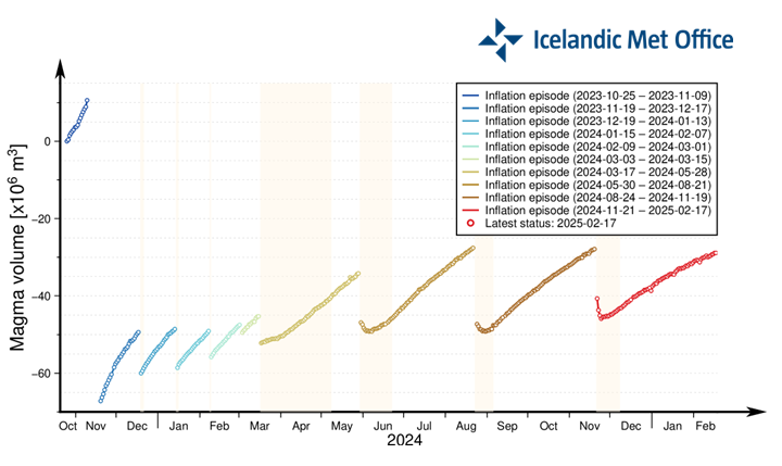
Image caption: Graph showing the development of magma accumulation and the estimated total volume of magma in the accumulation area beneath Svartsengi. The zero point indicates the volume before uplift began in late October 2023. The total magma volume beneath Svartsengi is now over 90% of what had accumulated before the eruption on November 20, last year.
Seismic activity on the Sundhnúksgígar crater row has remained similar over the past week, with around five or fewer earthquakes recorded per day. However, seismic activity in the area has been slowly increasing since late January.
The hazard assessment has been updated but remains unchanged. It is valid until February 25, unless conditions change.

(Click on the map to see it larger)
Updated 11. February at 17:30 UTC
Land uplift and magma accumulation under Svartsengi continues
The period of increased risk of a volcanic eruption risk may last up to a month or longer
Slight increase in seismic activity in recent weeks
Hazard assessment updated but remains unchanged
GPS measurements indicate ongoing land uplift beneath Svartsengi. Although, the rate of uplift has slightly decreased in recent weeks. However, model calculations show continued magma accumulation. The volume of magma has reached the lower threshold believed to be necessary to trigger the next dike intrusion and potential eruption.Past events at the Sundhnúkur crater row suggest that once the magma volume reaches this threshold, eruptions have occurred within a timeframe of a few days to four weeks. This does not guarantee that the next event will happen within a month, but experience suggests this is the most likely scenario.
Seismic activity has slightly increased in recent days. Looking at the number of earthquakes since the last eruption, a gradual increase has been observed since late January. However, stormy weather last week may have affected the sensitivity of the earthquake monitoring system, possibly preventing the detection of the smallest tremors.
The hazard assessment has been updated but remains unchanged and is valid until February 18, unless conditions change.
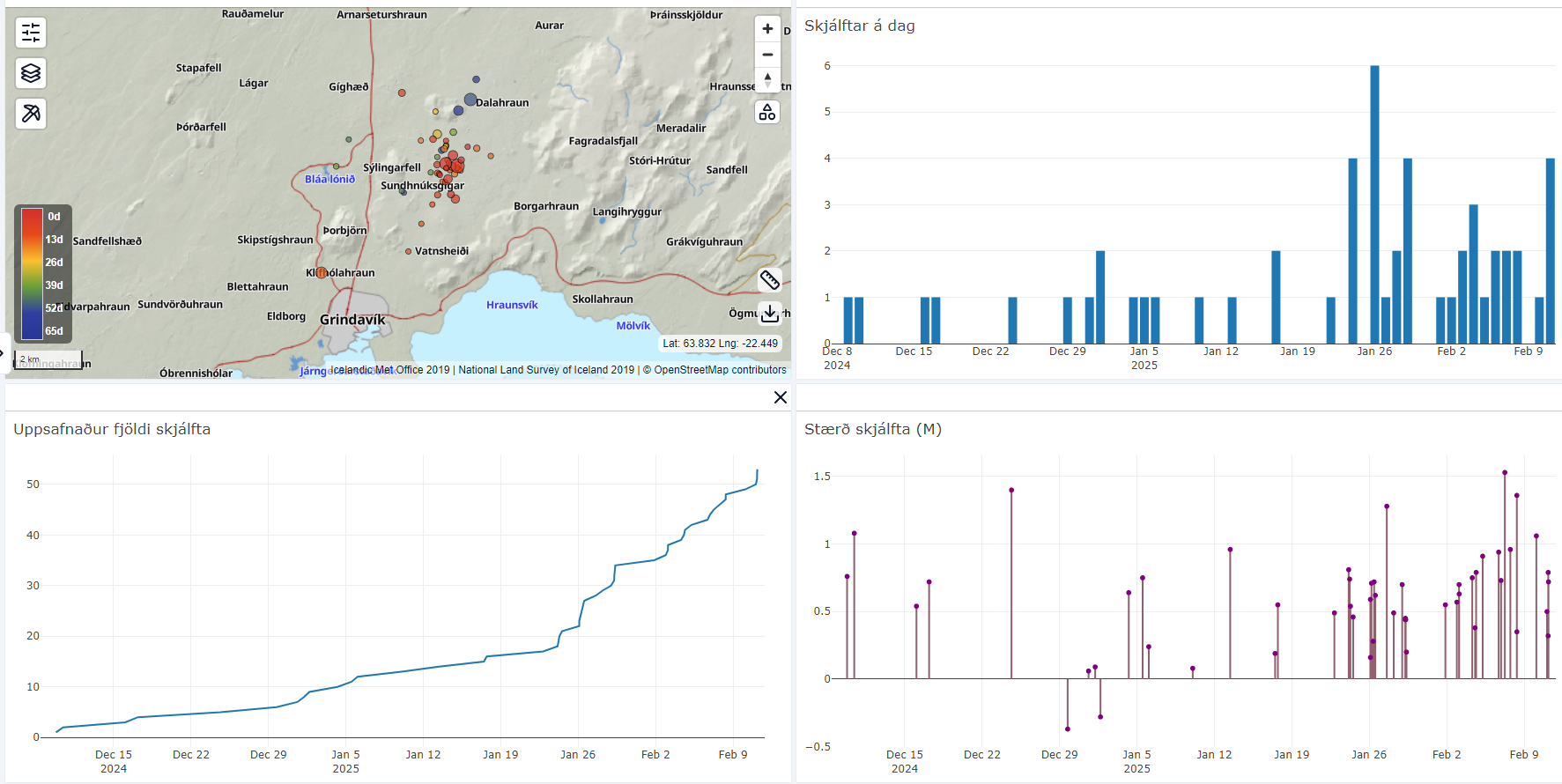
Seismic activity at the Sundhnúkur crater row since the end of the eruption on December 10. Top left shows a map that provides an overview of the development and location of earthquakes around the Sundhnúkur crater row. In the top right, a bar chart displays the number of earthquakes recorded each day. In the bottom left, a graph shows the cumulative number of earthquakes. In the bottom right, a graph illustrates the magnitude of the earthquakes.
Movements recorded at GPS station HS02 in the Svartsengi area since 11 November, 2023, showing displacement in north, east, and vertical directions (top, middle, bottom). The bottom graph represents land uplift in millimeters, with yesterday's (11 February) measurement marked by a green dot. Red lines indicate the onset of the last seven eruptions (18 December, 2023; 14 January, 8 February, 16 March, 29 May, 22 August, and 20 November, 2024). Blue lines represent magma intrusions that did not result in an eruption (10 November, 2023, and 2 March, 2024).
The Icelandic Meteorological Office hazard
assessment has been updated with no changes made. It remains valid, barring any
changes, until February 18.

Updated 4. February at 13:45 UTC
Weather conditions in the coming days could affect the monitoring capabilities
Magma accumulation beneath Svartsengi and the associated land uplift continues
The period of increased risk of a volcanic eruption risk may last up to a month or longer
Seismic activity remains low
Hazard assessment remains unchanged
The weather forecast for the coming days indicates a series of low-pressure systems moving across the country, bringing strong southwesterly and southerly winds along with precipitation. These weather conditions may affect measurement capabilities, particularly in terms of visibility and the sensitivity of seismic and real-time GPS measurements. The Icelandic Meteorological Office will continue to monitor the situation closely, and the public is advised to stay informed about weather warnings and exercise caution when travelling.
Deformation measurements continue to show ongoing land uplift and magma accumulation beneath Svartsengi. As reported last week, the amount of magma accumulating beneath Svartsengi is now approaching the lower threshold, believed to be necessary to trigger the next magma intrusion. If we look at the recent eruptions on the Sundhnúkur crater row, they have occurred anywhere between three days and four weeks after reaching this lower threshold. However, this does not mean that the next event will occur within a month, but rather that experience suggests this as the most likely scenario.

Movements recorded at GPS station HS02 in the Svartsengi area since 11 November, 2023, showing displacement in north, east, and vertical directions (top, middle, bottom). The bottom graph represents land uplift in millimeters, with yesterday's (3 February) measurement marked by a green dot. Red lines indicate the onset of the last seven eruptions (18 December, 2023; 14 January, 8 February, 16 March, 29 May, 22 August, and 20 November, 2024). Blue lines represent magma intrusions that did not result in an eruption (10 November, 2023, and 2 March, 2024).
Seismic activity near the Sundhnúkur crater row has remained low since the last eruption ended on 9 December. Only a few small earthquakes are being recorded daily. However, poor weather conditions and strong winds may affect measurement sensitivity.
The hazard assessment remains unchanged and is valid until February 11.
Updated 31. January at 16:00 UTC
Ground uplift and magma accumulation under Svartsengi continues
The volume of magma accumulating beneath Svartsengi is approaching the volume drop observed during the last event
The likelihood of a new magma intrusion or eruption is increasing
The period of heightened likelihood of an eruption could last up to a month or longer
Seismicity prior to the next eruption might be minimal
Weather conditions in the coming days could affect the monitoring capabilities
Severe weather has affected the entire Reykjanes Peninsula since yesterday. According to the forecasts, weather in the coming days may impact the monitoring and the response time in case of a a magma intrusion or eruption occurs. Strong winds, sleet, and snow could interfere with seismic measurements and reduce the accuracy of GPS monitoring of ground uplift.
The Icelandic Meteorological Office will continue to closely monitor developments, and people are encouraged to pay attention to weather warnings and exercise caution when traveling.
The period of increased likelihood of an eruption could last up to a month or longer
Model calculations are used to estimate the volume of magma which is accumulating beneath Svartsengi. This estimate is not a precise number but rather defines a range with "lower" and "upper" boundary. According to the latest models, the volume of magma under Svartsengi has now reached the lower boundary of the volume loss observed during the last event. Based on past eruptions, these models suggest that magma intrusions or eruptions tend to occur once this lower boundary is reached.
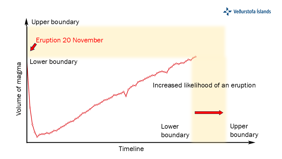
The graph shows model calculations of magma volume accumulating beneath Svartsengi over time. The y-axis represents volume of magma within the magma domain, and the x-axis represents time. Two thresholds are indicated: "lower boundary" and "upper boundary," which signify the range where the likelihood of magma intrusion and eruption increases.
As the lower threshold is reached, the likelihood of an eruption begins to grow. The model is based on ground deformation rates measured with GPS data, which indicate magma accumulation beneath Svartsengi. If the rate of ground uplift slows, indicating a reduction in magma accumulation, it could affect the calculations and alter the timing of the lower and upper boundaries.
Looking to those eruptions that occurred since January 2024, the time between reaching the lower boundary and the onset of an eruption in the Sundhnúks crater row has ranged from a few days to a month. Therefore, the period of increased likelihood for an eruption has different duration between events and may last up to a month or longer.
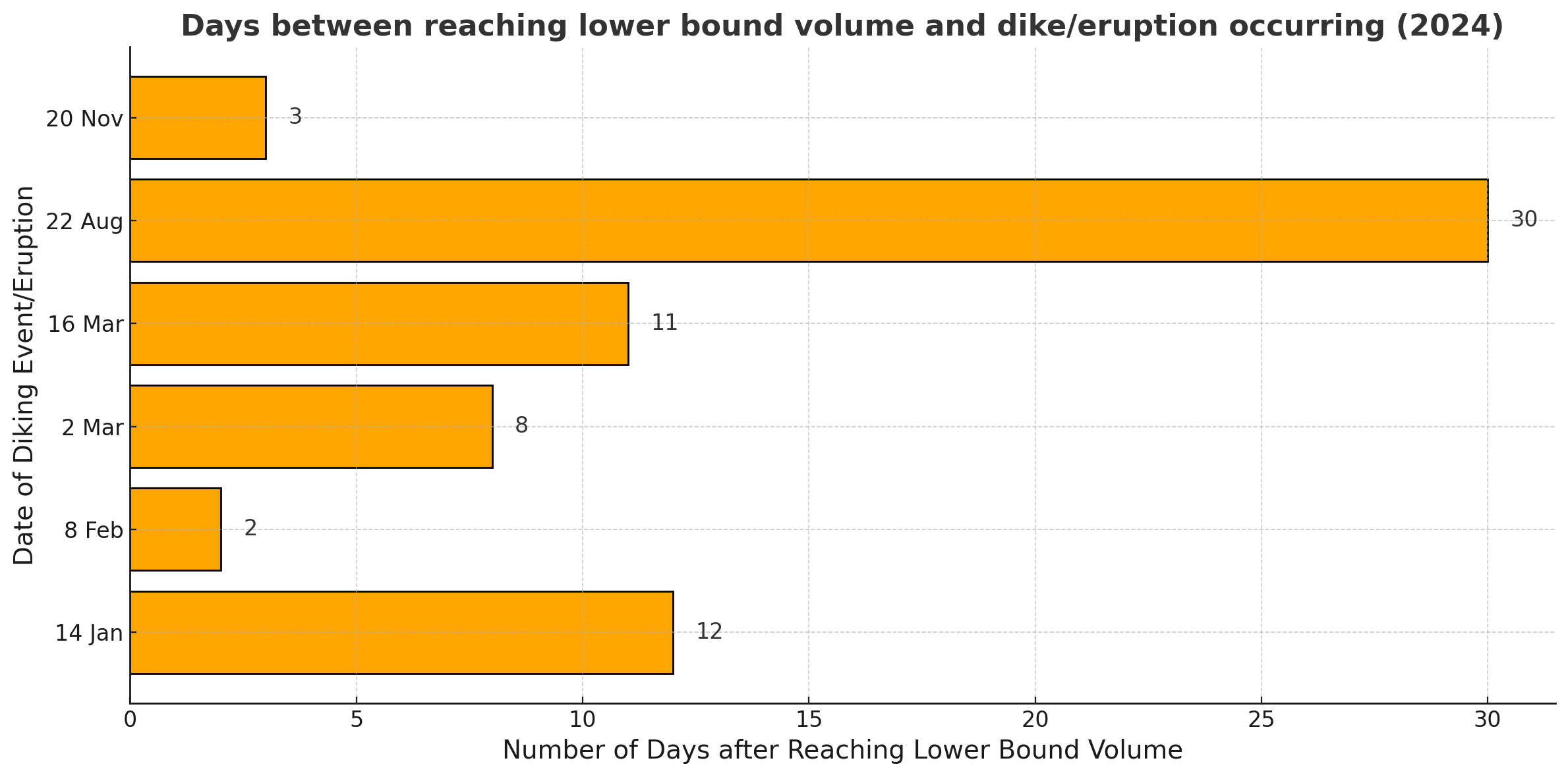
The graph illustrates the number of days between reaching the lower boundary and the onset of an eruption for six events which occurred in 2024. The y-axis lists eruption dates, while the x-axis shows the number of days elapsed from reaching the lower boundary. Note that the eruption which commenced on May 29 was excluded from this analysis, as it is believed that a system change occurred prior to this event.
Updated 28. January at 17:30 UTC
Ground uplift and magma accumulation under Svartsengi continues
The volume of magma accumulating beneath Svartsengi is approaching the volume drop that occurred during the last event
The likelihood of a new magma intrusion and potentially an eruption is increasing
There is a possibility that seismic activity may not be significant prior to the next eruption
The updated hazard assessment is valid until February 11, barring further developments
Deformation measurements indicate continued ground uplift and magma accumulation beneath Svartsengi. The sequence of events remains similar to those observed before the last eruptions. Modeling calculations show that the volume of magma accumulating beneath Svartsengi is nearing the volume drop that occurred during the last event.
Based on the analysis of previous events, scientists have assessed that once a similar volume of magma has accumulated beneath Svartsengi as during previous eruptions, the likelihood of a new magma intrusion and even an eruption increases.
New hazard assessment reflects increased eruption likelihood
The Icelandic Meteorological Office has updated the hazard assessment, which is now valid until February 11, barring any changes. It has been decided to raise the hazard level in zones 4 and 6 from “moderate” (yellow) to “considerable” (orange). This change is based on modeling calculations indicating that the volume of magma accumulating beneath Svartsengi is nearing the volume drop that occurred during the last event.
According to the weather forecast, severe weather is expected to occur in the coming days, beginning January 30.throughout the week. A southern storm accompanied by significant warming, rain, and drizzle is forecasted for southern and western parts of the country later this week and into the weekend. Adverse weather could reduce the sensitivity of the monitoring network, potentially delaying response times to an eruption.

(Image of the updated hazard map)
Little seismic activity could precede the next eruption
Seismic activity in the Sundhnúkar crater row has been increasing gradually since the end of the eruption on December 9, 2024, but overall it remains low. Developments over the past year suggest that seismic activity prior to magma intrusions has been decreasing with each event. Consequently, there is a possibility that seismic activity may not be significant prior to the next eruption.
Seismic activity near the Sundhnúkar Crater Row, displaying the number of earthquakes per day since December 2024.
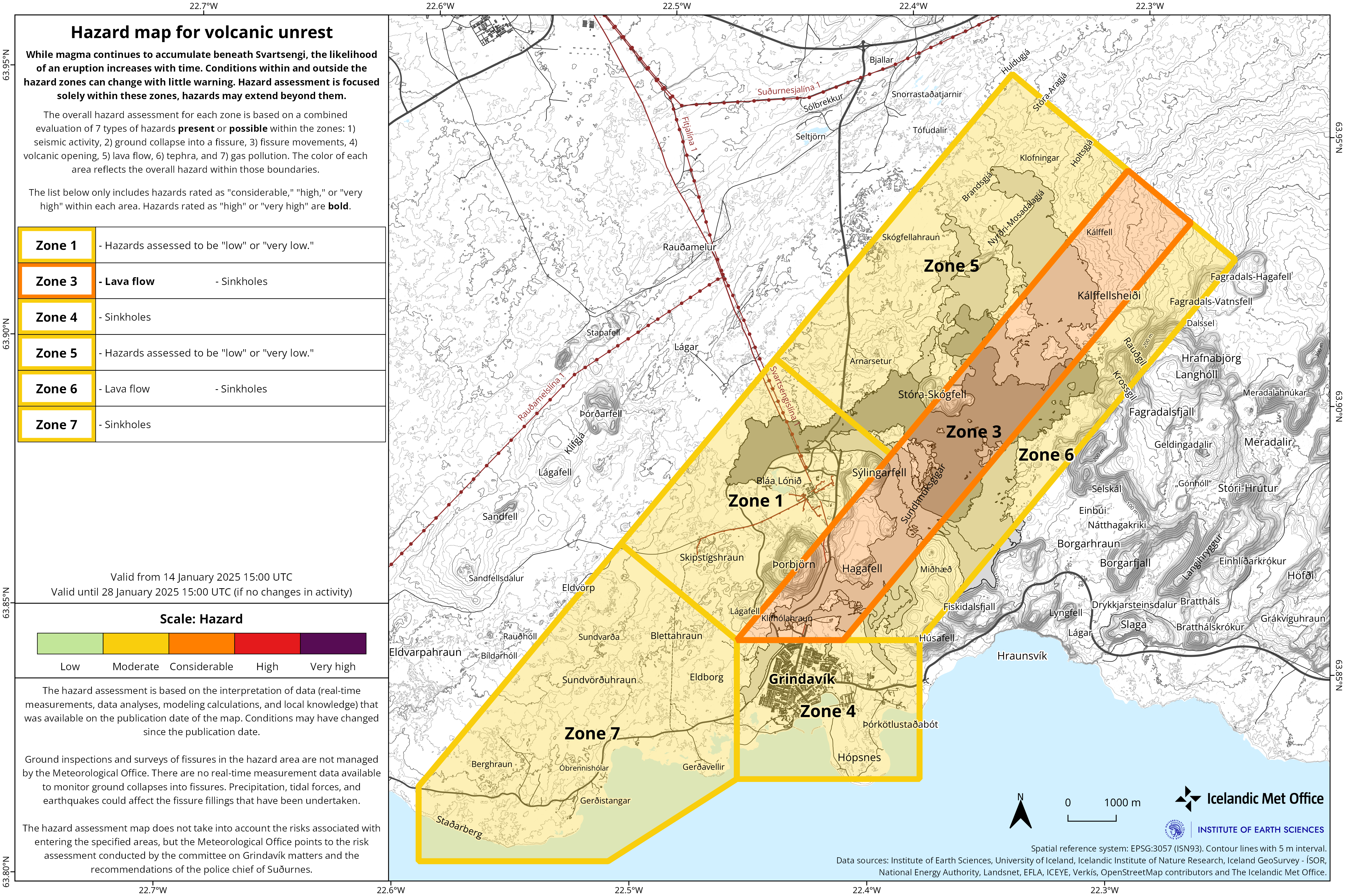
Updated 14. January at 15:05
Seismic activity remains relatively low
Latest data suggests that the likelihood of magma intrusion and potentially an eruption will increase end of January
Updated hazard assessment valid until January 28, 2025, unless conditions change
Land uplift in the Svartsengi area continues at a similar rate to previous
weeks. By the end of January or beginning of February, the likelihood of an
eruption starts to increase, as model calculations indicate that approximately
12 million cubic meters of magma will have accumulated beneath Svartsengi by
that time. The models are based on estimated magma inflow rates, but minor
changes in inflow could impact the estimated timing of the next eruption.
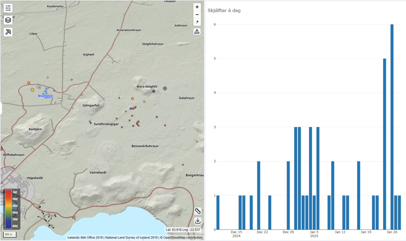
Seismic activity around Svartsengi remains low, similar to recent weeks.
The Icelandic Meteorological Office hazard assessment has been updated with no changes made. It remains valid, barring any changes, until January 28.
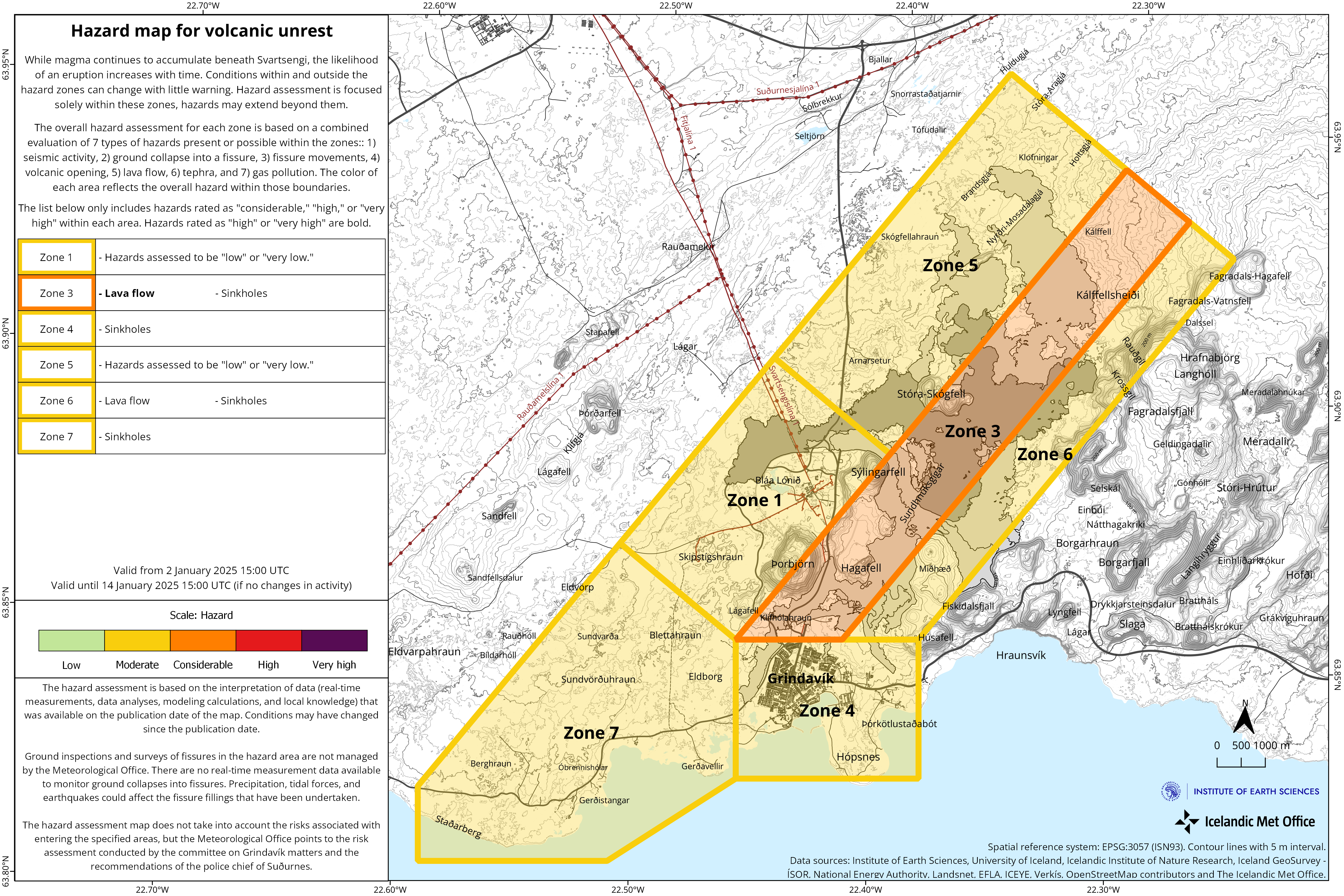
- Latest data suggests that the likelihood of magma intrusion and potentially an eruption will increase as of January.
- Geodetic model results estimate magma inflow rates similar to the rate leading up to the last eruption.
- Updated hazard assessment valid until January 14, 2025, unless conditions change.
Deformation data up to December 30, 2024, indicates that magma accumulation beneath Svartsengi continues.
The likelihood of a new magma intrusion and potentially an eruption is expected to increase when the volume of magma beneath Svartsengi matches the amount that left the magma region during the magma intrusion and eruption on November 20. Geodetic model results estimate this volume to be between 12 and 15 million cubic meters.
According to the latest deformation data, the magma inflow rate is currently estimated at just over 3 m³/s, similar to the rate observed before the last eruption. If magma accumulation continues at the current rate, the magma volume beneath Svartsengi is projected to reach 12 million m³ by late January and approximately 13.5 million m³ by the first week of February. Therefore, the likelihood of magma intrusion and potentially an eruption along the Sundhnúkur crater row may increase as of late January.
These estimates are based on calculated magma inflow rates over time, and small changes in these rates can affect projections for the timing of a potential eruption.
Lava Field Remains Hazardous to Hikers
The Icelandic Meteorological Office's hazard assessment has been updated and remains valid, barring any changes, until January 14, 2025.
The main change concerns Zone 6, where the overall hazard level has been revised from significant (orange) to moderate (yellow). The overall hazard in Zone 6 is now considered lower due to a reduced lava flow hazard. However, while the danger due to the lava flow is currently deemed lower, the existing lava field remains hot and dangerous to cross.
Earthquake Swarms Near Eldey Common in Recent Years
Seismic activity has been minimal along the Sundhnúkur crater row since the last eruption ended on December 8, 2024.
However, some seismic activity has been recorded in other nearby areas. Approximately 200 earthquakes, including two over magnitude 3, were detected during a swarm from December 29–31, 2024, near Eldey on the Reykjanes Ridge. Earthquake swarms near Eldey have been frequent in recent years, with nearly 60 earthquakes over magnitude 3 recorded there in the past four years.
While occasional earthquakes are still being detected, the swarm has mostly subsided. Regular small earthquakes continue to occur in the western part of Fagradalsfjall, where over 60 minor earthquakes have been recorded in the past month, most at depths of 6–8 km.