The activity in the Reykjanes Peninsula has entered a new phase
Updated 10 August 2023
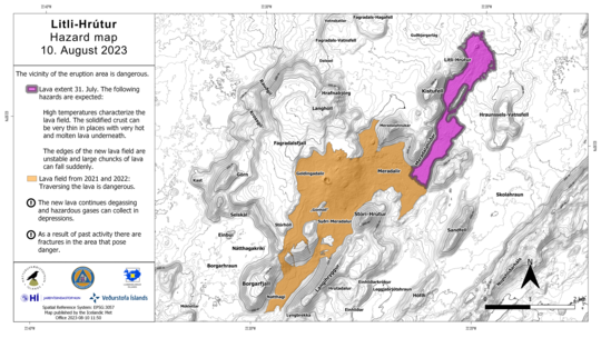
The Icelandic Met Office has updated the hazard map for the eruption site. The vicinity of the eruption area is still dangerous. High temperatures characterize the lava field. The solidified crust can be very thin in places with very hot and molten lava underneath. The edges of the new lava field are unstable and large chunks of lava can fall sudden. As a result of past activity there are fractures in the area that pose danger. The new lava continues degassing and hazardous gases can collect in depressions
Updated 8 August 2023
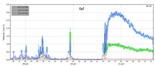
The activity in the Reykjanes peninsula has entered a new phase. At the end of last week it was possible to see the crater, feeding the eruption in Litli-Hrútur, shrinking and reducing its size. At the same time, starting on midnight on August 4, volcanic tremor started declining in a stable manner as measured by many stations close to the eruption site. At midday August 5, the tremor detected at the station located at Hraunsel-Vatnsfell (HRV), right at the eruption site, decreased further reaching pre-eruptive levels (see the image below). No activity has been observed at the crater since then. Seismic activity in the area continues, but it is now much less intense compared to the beginning of the eruption. The last thermal anomaly detected by satellite (MODIS) was on August 6.
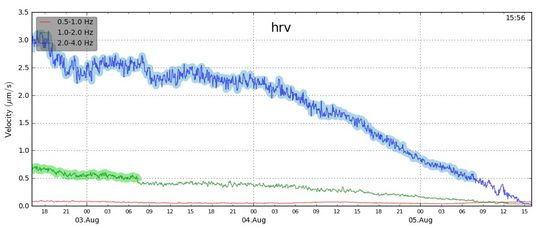
It is still too early to declare that the eruption at Litli-Hrútur is over, though it appears evident that a new phase of the eruptive activity in the Reykjanes peninsula has started. It is premature to anticipate if the seismic activity will increase again and a new eruption will begin in the future, or not. Only time will tell.
Most importantly, there are still hazards in the area around the eruption site. The hazard area as issued by the Icelandic Met Office is still valid and there will be no changes until a new hazard assessment will be completed at the end of this week.
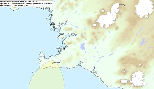
Considering the absence of eruptive activity, the IMO has suspended daily forecast for gas pollution, but visitors to the eruption site need to be aware that persistent lava degassing is still occurring, and events of gas pollution cannot be excluded in the vicinity of the eruption site.
Updated 2 August 2023
New data were acquired on 31 July and the processed results were published yesterday on Earth Science department's website. The data show an extrusion rate of about 5 m3/s for the period 23-31 July. This estimate is lower than the previous one taken on 18 July which indicated a lava discharge rate of about 9 m3/s, revealing a further reduction in the intensity of the eruption. Considering the averaged discharge rate over the last few days, we could assess that the rate is just 3-4 m3/s as of today, as reported on ES's website.
On the 31 July the lava field has extended over an area of 1.5 km2 and a total of 15.9 million m3 of lava has been released.
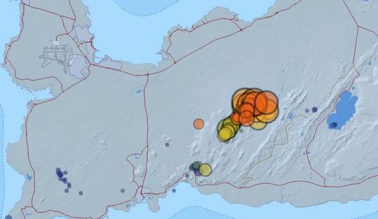
Since the 26th of july there have been about 150 earthquakes
in and around the active area. Activity has been focused by Mt. Keilir which is
the northernmost part of the intrusion dike. The largest earthquake during this
period was a M2.1 located on the west side of Mt. Keilir. Few earthquakes are being
measured at the active eruption area but there is still some activity happening
NE of the main activity zone, these are so called trigger earthquakes directly
related to the crust deformation due to the dike intrusion.
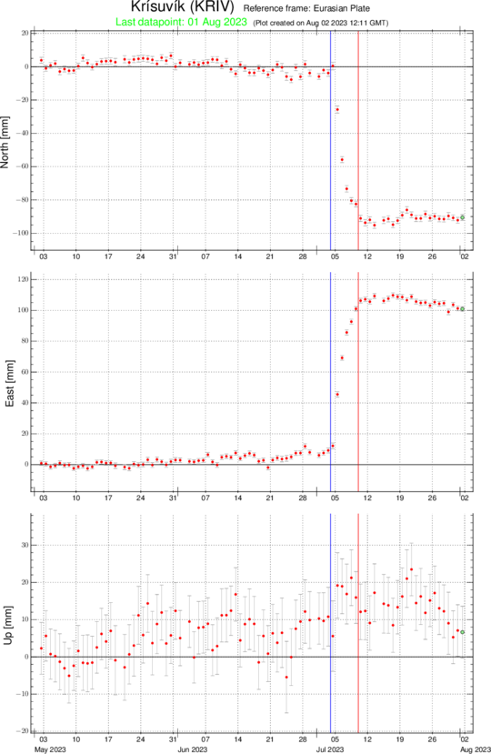
The GPS data indicates signs of deflation at depth
which probably coincides with the deep source feeding the eruption. New InSAR
images will be acquired next week, and they will help reassess the ongoing deformation
processes occurring in the whole area around the eruption site. (The red line in the image above marks the beginning of the eruption)
Later today a team from IMO will perform a DOAS traverse to provide an updated estimate of SO2 release from the eruption.
The overall dataset confirms that the eruption is slowly decreasing, and it might possibly come to an end in the coming days/weeks.
Updated 25 July 2023
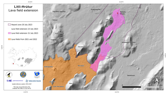
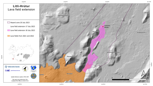
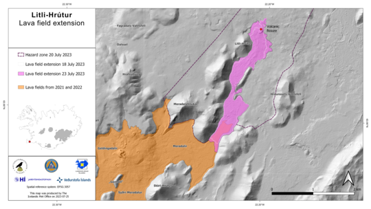
The map below shows the latest lava field extension in accordance with the data acquired by the University of Iceland, the Icelandic Institute of Natural History and the National Land Survey of Iceland on 23 July. The latest measurement indicates an average effusion rate of 8.0 m3/s for the period 18-23 July. After two weeks of activity, the lava field covers now an area of about 1.2 km2 and the total erupted volume is about 12.4 million cubic meters. More information on the measurements are available on Earth Science Institute webpage.
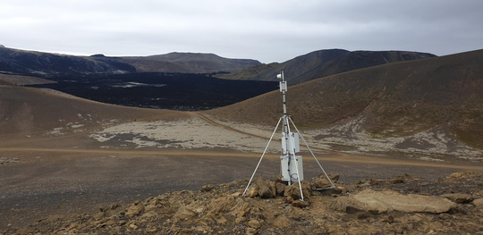
The Icelandic Met Office, in collaboration with the Civil Protection Department of Iceland, has set up a web camera for monitoring the possible lava flow advancement out of Meradalir and further to the South. At least two times the lava flow spread out from the main vent in Litla-Hrút toward other directions, delaying its propagation to the South. At this stage it is difficult to assess if and when lava flow will reach the ridge at the edge of Meradalir.
The web camera is situated on Sandfell, looking west towards Meradalir. (Photo: The Icelandic Met Office/Hákon Halldórsson)
Updated 20 July, 2023
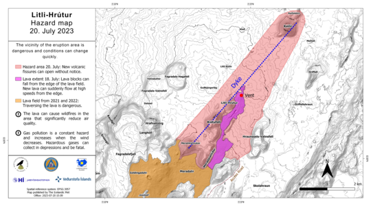
An updated hazard map has been prepared for the eruption site at Litli-Hrútur. The new map shows the revised location of the dike intrusion between the 4-10 July 2023, based on both new deformation modelling and seismic relocations. The dike intrusion which was emplaced prior to the eruption onset extends from Keilir in the north to Meradalahnúkar in the south.
Click on the picture to view a bigger version
The Icelandic Met Office meets SST each day at 9 in the
morning for an update and overview of the ongoing activity. Indications and
information on hazards and forecasts are provided regularly during such
meetings in support of the operations in the field.
We would like to remind anyone visiting or accessing the eruption site, that this eruption continues to present significant hazards which may evolve and/or occur with very little or no warning time. They include:
- Gas emissions: Sustained and localized gas pollution that increases when winds are lower. Dangerous and potentially fatal gas levels may accumulate in topographic lows
- Lava flows and rapid outflows of lava due to crater collapse or changes in topography (e.g. rapid outpourings of lava over escarpments)
- Blocks of lava which may fall from the lava´s edge accompanied by sudden advances of new lava from and over the edge at speeds that one may potentially not outrun
- Openings of new eruptive fissures without any warning
- Moss fires: Lava can ignite vegetation fires that can dramatically decrease air quality at the site
People who enter the area should make themselves aware of these hazards and the designated hazard zone which should by no means be entered. We also advise visitors to the site to check the wind direction, gas forecast and the level of gas pollution in the area before hiking. Dust masks to protect themselves in the event of additional moss fires are also recommended.
Lave flow rate comparable to those measured during previous eruptions
The activity is now focussed on one crater. Early morning on the 19th there was a partial collapse of the main crater caused a large and sudden release of lava on the western side. The event was preceded by an increase in eruption tremor which lasted about 5 hours followed by a sudden drop. A few hours after the event lava started to flow south again, following the incline in the landscape.
The average lava flow rate between the 17th and 18th of July is estimated to about 8,7m3/ according to the latest data published at the University of Iceland. This rate is well comparable to those measured during previous eruptions in Fagradalsfjall. As of 18 July, the area of the new lava field was determined to be 0.92 km2 and the volume of erupted lava at about 9 million cubic meters.
Click on the picture to view a bigger version
A volcanic gas plume rises from the main crater and calibrated cameras estimate its height to be between 1-2 km above sea level. The SO2 flux has been similar to previous eruptions showing fluctuations within a range of 30-130 kg/s according to DOAS measurements. Grass and moss fires continue in the area, but firefighters have managed to put most of them out.
Updated 13 July 2023 at 14:30
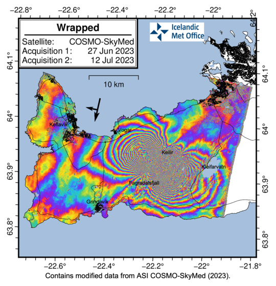
This COSMO-SkyMed interferogram covers the period from 27 june to 12 july 2023 and shows ground deformation leading up to and during the first two days of the eruption. Each coloured fringe cycle represents 1.55 cm of deformation in the satellite‘s line-of-sight. In relation to the dike intrusion, over 50 cm of extensional motion is observed in both the NW and SE directions (~ 1 m of outward movements in total across the interferogram). These outward movements occur perpendicular to the axis of the dike, and represent expansion to the NW and SE, in response to magma inflow into the dike. As was reported yesterday, GPS observations since eruption onset show that deformation is returning to background suggesting balance between inflow of magma and outflow in the eruption. At the same time seismicity has decreased significantly supporting this interpretation.
COSMO-SkyMed interferogram covering the period from 27 june to 12 july 2023 and shows ground deformation leading up to and during the first two days of the eruption. Each coloured fringe cycle represents 1.55 cm of deformation in the satellite‘s line-of-sight. (Data from ASI COSMO-SkyMed).
Updated 12. July 2023 at 2:00pm
Since the eruption began Monday afternoon, July 10th, around 300 earthquakes have been recorded on the Reykjanes Peninsula. Most of the earthquakes have been below 2.0 in magnitude, but two have been measured larger, they were 2.0 and 2.1 in magnitude. This image below shows the evolution of the eruption over the last three days. Before the eruption, tremors are most noticeable on the graph. The unrest can be seen rising rapidly from 3pm on Monday, July 10, and peaked around 9pm. The tremor graph shows tremor at three different frequencies, and it is clearly seen that the eruption tremor is greatest at the highest frequency, 2-4 Hz. Now that the eruption has begun, it can be expected that the seismic activity in the area will continue to decrease.
Updated 11. July 2023 at 6:00pm
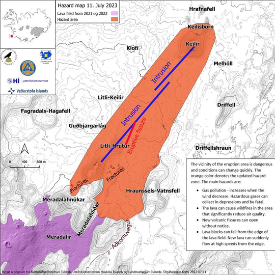
New Hazard map has been made according to the vicinity of the eruption area, it is dangerous and conditions can change quickly. The orange color denotes the updated hazard zone. The main hazards can cause gas pollution - increases when the wind decrease. Hazardous gases can collect in depressions and be fatal. The lava can cause wildfires in the area that significantly reduce air quality. New volcanic fissures can open without notice. Lava blocks can fall from the edge of the lava field. New lava can suddenly flow at high speeds from the edge.
Click on the map to see it larger.
Updated 11. July 2023 at 12:50pm
Key points:
- A lava-producing fissure eruption is occurring close to Litli-Hrútur mountain on the Reykjanes Peninsula.
- The eruption is occurring in an uninhabited area and it poses no immediate dangers to infrastructure.
- The intensity of the eruption has decreased considerably during the first 24 hours
- Volcanic ash is not being produced by the eruption.
- Close to the eruption, the main hazards are incandescent, flowing lava and volcanic gases.
- New ICEYE interferogram covering the period
from 9 to 10 July 2023 shows that the deformation related to the dike intrusion
between Fagradalsfjall and Keilir had progressed approximately 1 km further
northeast (compared to Saturday 8 July)
- Gas measurements at the eruption site during the first hours show levels similar to the 2022 eruption.
- Flowing lava could also cause localised grass fires, which will further contribute to poor air quality close to the eruption site.
New data shows that the magma intrusion reaches under Keilir with deformation on the surface between Litli-Hrútur and Keilir. Highest likelihood of new eruption vents, should they open, is however still at Litli-Hrútur.
The intensity of the eruption by Litli-Hrútur mountain on Reykjanes has decreased dramatically since it started on 16:40 Monday 10 July 2023 with fewer and lower lava fountains compared to at the start. The seismic tremor (ground noise) due to the eruption reached a peak between 21:00 UTC and midnight Monday 10 July and has shown a steady decline between midnight to 11 on Tuesday 11 July. The most likely reason is the reported decrease in effusive rates of magma and gases and lava outflow concentrating on fewer vents.
New ICEYE interferogram covering the period from 9 to 10 July 2023 shows that the deformation related to the dike intrusion between Fagradalsfjall and Keilir had progressed approximately 1 km further northeast (compared to Saturday 8 July), reaching under Keilir mountain. Moreover, it shows narrowing of bounding faults of the dike in the vicinity of the eruptive fissure that formed at the eastern base of Litli-Hrútur mountain and northeast of it between Litli-Hrútur and Keilir. This is the same location as the dike intrusion, as inferred from earlier modeling.
The lava flow is currently mostly channeled to the southeast and into a shallow valley south of Litli-Hrútur that will most likely fill in a short time and continue towards south. Lava may potentially also likely flow towards southeast of a small ridge at the edge of the shallow valley. From there likely flow paths are towards the south and around the ridge. Currently the lava is not flowing westward and northward from the eruption site. Should lava continue to flow southwards it is expected to eventually flow into and over the 2022 Merardalir lava flow.
Consistent with observations from the 2021 and 2022 intrusions, GPS measurements further away now show very little deformation, and seismicity in the region has decreased substantially. Earthquake activity today is almost exclusively concentrated around Keilir and towards Kleifarvatn, where most triggered earthquake activity was observed during last week's dike intrusion. However, just before the eruption, small earthquakes at very shallow depths had been detected under Litli-Hrútur.
It is important to note that in the vicinity of the eruptive fissures and lava field the conditions can change quickly. We advise people from staying at the eruption site due to the following key hazards:
- Sustained and localized gas pollution that increases when winds are lower. Dangerous and potentially fatal gas levels may accumulate in lows
- Lava can ignite vegetation fires that dramatically can decrease air quality at the site
- New eruption fissures may open near the existing vents without very little notice
- Chunks of lava may fall from the lava´s edge along with sudden advances of new lava from and over the edge at speeds that one may potentially not outrun
Updated 10. July 2023 at 6:30pm
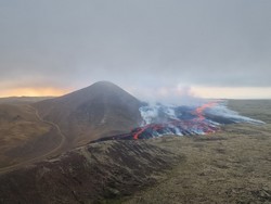
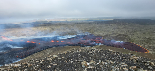
At 16:40 today, 10 July, a minor volcanic eruption began close to Litli Hrútur in Reykjanes Peninsula, situated between Fagradalsfjall and Keilir mountains. The eruption is small and there is presently no emission of ash to the atmosphere. From first estimates, there is a 200-m-long fissure oriented approximately northeast-southwest on the eastern and northeastern slopes of Litli Hrútur from which lava is emerging as a series of fountains. At the time of writing, the eruption is occurring in a small depression and lava is flowing to the south, while gas and steam emissions are drifting to the northwest. The eruption is in an uninhabited region, so there are no immediate risks to communities or infrastructure. The development of the eruption is presently unclear, so we advise the public not to attempt to visit the eruption area. Dangerously high levels of volcanic gases will accumulate close to the eruption. Further updates from IMO will be issued in the coming days.
During the prelude to the eruption, IMO scientists became aware of increasing levels of tremor at a seismic station at Fagradalsfjall. Episodes of heightened tremor occurred on 8 and 9 July, and again today in the hours before the eruption broke the surface. Similar periods of tremor were noted just ahead of similar eruptions on the Reykjanes Peninsula in 2021 and 2022. For further details about volcanic activity on Reykjanes Peninsula and in Iceland, see the Catalogue of Icelandic Volcanoes.
Further information about volcanic systems on Reykjanes Peninsula is available from the Catalogue of Icelandic Volcanoes.
Updated 9. July 2023 at 6:30pm
Today marks 5 days since the onset of the seismic sequence between Fagradalsfjall and Keilir caused by a magmatic intrusion just north-east of the location of the 2022 dike intrusion that resulted in an eruption 5 days later.
Deformation in the area continues to slow down and seismicity is relatively quiet around the dike location.
Triggered seismicity northeast of Keilir and in the region between Keilir and Kleifarvatn continued with earthquakes at Kleifarvatn last night (8 July) the largest being magtnitude 4.6. It was widely felt in the Southwest region, in particular due to its closer proximity to the capital region than the dike location. Rockfall was reported in mountains by Kleifarvatn and Trölladyngja, including some rockfall on nearby roads.
A one-day ICEYE interferogram, spanning the 7-8 July 2023, constrains the location of the dike related deformation as of yesterday afternoon. The interferogram shows deformation related to continued inflow of magma into the dike as well as significant surface deformation related to movements on NE-SW trending faults and possible graben formation.
Geodetic modeling results based on the new ICEYE interferogram show that the magma continues to reach shallower depths, now estimated to be at half a kilometer below the surface. The modeling indicates that as of yesterday afternoon, the dike was not propagating further to the north or south, but remained at a relatively stationary location between Litli Keilir and Litli Hrútur, with a length of approximately 3 km. However, the dike continues to inflate and migrate upwards.
These measurements and modeling results indicate that magma is moving closer to the surface, with an eruption being a highly likely scenario, although the timing is still uncertain (hours to days).
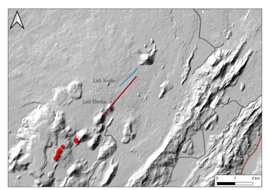
Modelled location and extent of surface deformation related to fault
movement, based on ICEYE interferogram 7-8 July (blue) and the modelled
location of the dike intrusion (red). The eruptive vents from 2021 and
2022 are shown as red stars. Topography by IslandsDEM and roads from the
National Land Survey of Iceland. Dike and fault locations mapped by Michelle M.
Parks, Vincent Drouin, Icelandic Meteorological Office; Ásta Rut Hjartardóttir,
University of Iceland.
Updated 7. July 2023 at 4:15pm
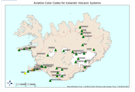
Shortly before midnight on 6 July a seismic sequence commenced close to Eldey island on Reykjanes ridge, approximately 10 km southwest off of Reykjanes peninsula. At 15:00 today (7 July) over 480 earthquakes have been measured there. Thereof 38 earthquakes have been manually analysed and checked. Ten earthquakes larger that 3 and six larger than 4 have occurred, the largest being 4,5 in magnitude at 5:06 this morning. Earthquake sequences in this area are not uncommon but this current activity is unusually high. In light of that the aviation colorcode, for Eldey volcanic system, will be changed to yellow.
Updated 7. July 2023 at 1:30pm
Since the onset of the seismic swarm in the Reykjanes peninsula, on 4 July, 7000 earthquakes have been recorded in the area between Fagradalsfjall and Keilir. Roughly 300 earthquakes have been manually checked. This activity is caused by a new dike intrusion in the area, namely between Fagradalsfjall and Keilir and its centre is believed to be between Litli-Hrútur and Litli-Keilir. A total of 17 earthquakes larger than 4 have been recorded and 50 events larger than 3. The largest earthquake occurred at UTC 8:21 on 5 July and was 4,8. The largest earthquakes are felt widely in the SW-area, from Hella to the east and towards Snæfellsnes peninsula in the north. A continuation of this activity is expected but seismic activity has decreased somewhat in the vicinity of the dike. Seismic activity has continued in the area between Keilir and Fagradalsfjall, which is interpreted to be triggered events.
In spite of decreasing seismic activity, deformation seen in GPS and InSAR records strongly suggests that magma is migrating towards the surface. Interferogram (InSAR) images based on satellite radar data showing deformation occurring between 28 June to 6 July confirm the results from IMO's GPS and seismic data regarding the magmatic intrusion . Model calculations based on the interferogram and GPS data suggest that the upper level of the dike reached 1 km depth early yesterday (6 July) causing a fracture of a 2.8 km length between Fagradalsfjall and Keilir, with a centre just north of Litli-Hrútur. These results are in good agreement with the seismic activity. The calculations also suggest that magma inflow rate is almost twice as fast compared to the antecedent of the eruption in August 2022, but the total volume of magma which has reached the upper part of the crust is similar, around 12 million cubic metres. The most recent GPS data indicates that magma is still migrating closer to the surface.
Presently, over 400
earthquakes have been recorded on the Reykjanes ridge, closer to Eldey. Of those,
35 events have been checked. About ten earthquakes larger than 3 have been confirmed
and six larger than 4, the largest one measuring 4,5 which took place today 7
July 2023 at 5:06. Although seismic swarms are not uncommon in this area, this activity
is now unusually high. Heightened activity on the Reykjanes ridge now is potentially
triggered by the dike intrusion in Fagradalsfjall, but other causes cannot be ruled
out. Deformation data do not suggest that the activity is caused by magma movement,
but further research and data is needed.
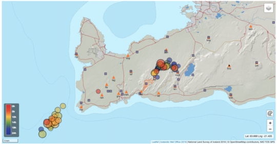
Seismicity in Reykjanes
(magnitudes larger than 2) from noon to noon 6-7 July 2023. The symbols show
locations of GPS and seismic stations of the Icelandic Met Office, and the outlines
of the Fagradalsfjall 2021 and 2022 lava field is shown for scale.
Updated 6. July 2023 at 6pm
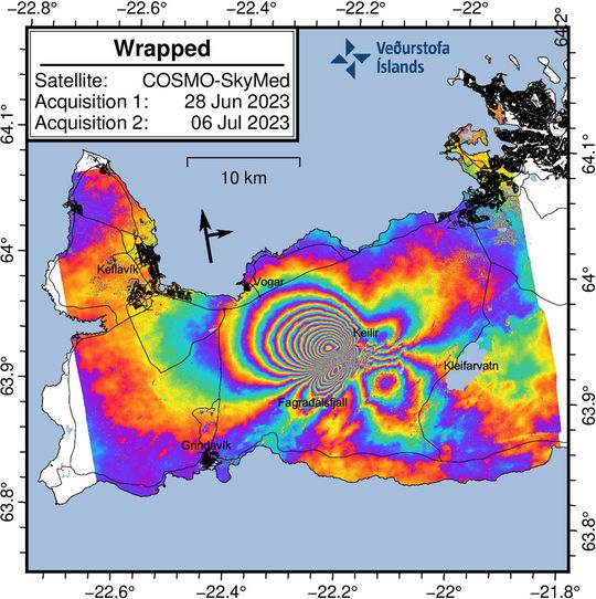
COSMO-SkyMed interferogram covering the period 28 June to 6 July 2023.
The wrapped image clearly shows a series of multicolored fringes centered bewtween Fagradalsfjall and Keilir. These fringes show ground deformation caused by the new dike intrusion which commenced on 4 July 2023. The maximum observed deformation related to the dike intrusion is up to 18 cm in the satellite‘s line-of-sight (los) in the NW direction.
Although the deformation signal extends over a large area of the western Reykjanes Peninsula, this does not mean there is magma beneath this entire region. The magma intrusion is situated bewteen Fagradalsfjall and Keilir. There is no indication of additional magma movements outside this area.
Several small lineaments are also visible in the interferogram which cut across the fringes. These represent fault movements/earthquakes that were triggered during the dike propagation.
Updated 6. July 2023 at 12:30pm
The earthquake swarm on the Reykjanes Peninsula continues, with over 1300 earthquakes detected since midnight today, 6 July. Since the beginning of the swarm on 4 July, the total number of earthquakes exceeds 4700. From midnight today, over six earthquakes exceeding magnitude 3.5 have occurred, with the largest earthquakes continuing to be felt in the south-west of the country. Overall, the intensity of the swarm has decreased slightly, both in terms of number of earthquakes and earthquake magnitudes.
The spatial distribution of earthquake epicentres is on a northeast-southwest lineament between Fagradalsfjall and Keilir, mostly concentrated just north of the mountain Litli Hrútur. The latest ground deformation (GPS) observations show significant movements, indicating magma propagation in the region where earthquakes are highly concentrated. The likely explanation is a northeast-southwest trending magma intrusion at 2 to 4 km depth. The intrusion is close enough to the Earth's surface that a volcanic eruption could occur without further escalations in seismic activity or ground deformation.
Based on the present assessment, two outcomes are possible. The seismicity could decrease progressively without magma reaching the surface. Alternatively, the seismicity could still decrease when the magma stops moving laterally but begins to move upward towards the surface (as observed prior to the last 2 eruptions here). This would likely result in an eruption close to where seismicity is currently concentrated. However, magma reaching the surface anywhere in the region between Fagradalsfjall and Keilir cannot be excluded. Of the two possible outcomes, a volcanic eruption occurring within days or weeks is considered more likely.
While the earthquake swarm is ongoing, the main hazard is strong seismic ground motion due to the largest earthquakes in the sequence and potential triggered earthquakes on nearby faults. The largest earthquakes in the swarm have caused localised rockfalls, so people are advised against walking close to rock cliffs or steep slopes in the area around Keilir, Fagradalsfjall and Kleifarvatn.
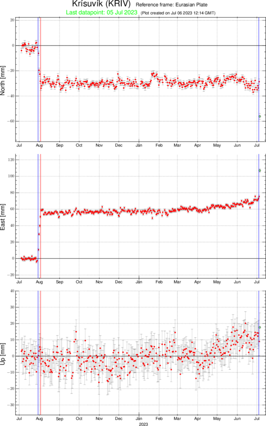
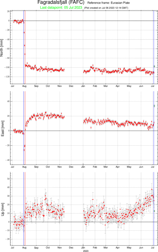
The images show data from the GPS stations FAFC (Fagradalsfjall) and KRIV (Krísuvík). FAFC is located just south of the activity and KRIV which is about 8 km south-east of it. The blue lines show the beginning of the intrusions, while the red lines show the beginning of the eruptions. The station KRIV shows > 30 mm displacement to the southeast, reflecting magma being intruded into the upper part of the crust. The FAFC located just south of the activity shows a mixture of signals due to the vicinity to the activity. The entries are similar to the lead-up to the August 2022 eruption, except the northern component of the FAFC which shows north- but not south-ward movement, reflecting that the magma is north of the station, but was south of it in 2022.
Updated 5. July 2023 at 2:30pm
Earthquake activity commenced around 14:00 UTC yesterday (4 July 2023) beneath the Fagradalsfjall region on the Reykjanes Peninsula, followed by an intense seismic swarm at 16:30 which is still continuing. By noon today ~2200 earthquakes have occurred since the onset of this activity.
The epicentral distribution of the seismicity is narrow and aligned northeast-southwest, between Fagradalsfjall and Keilir.
The seismicity
started beneath the known magma upflow region beneath Fagradalsfjall (in the
vicinity of the July 2022 dike intrusion) with earthquake depths initially
around 8 km, shallowing to approx. 4 km within 5 hours.
As of this morning (5 July 2023), seismicity has now reached depths of ~ 2-3
km.
The earthquake magnitudes have also increased during the sequence, with more than seven earthquakes of magnitudes larger than 4 occurring from 7:30 UTC this morning (5 July 2023).
The activity is consistent with the three seismic sequences in 2021 (February-March and December) and 2022 (July-August) that were caused by vertical dike intrusions along the same lineament. Two of these intrusions culminated in an eruption (March 2021 and August 2022).
The current sequence is characteristic of a new dike intrusion beneath the Fagradalsfjall area, extending to the northeast towards Keilir. Specifically, the earthquake activity is similar to what was observed last summer when a dike began propagating in the same area beneath Fagradalsfjall on 30 July 2022 and culminated in an eruption 4 days later (3 August 2022).
The current activity is considered to be heightened unrest with an increased likelihood of an eruption within the coming hours to days.
There is a possibility the activity may cease without an eruption. However, based on current seismicity and similarities with the 2022 dike intrusion the likelihood of an impending eruption is considered high.
The stress changes associated with the intrusion may trigger earthquake activity on nearby faults along the Reykjanes peninsula.
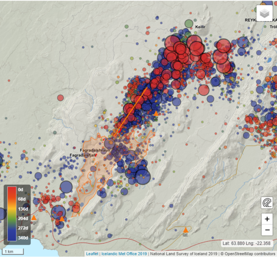
On this figure we see distribution of earthquake
epicentres (circles) in the Fagradalsfjall region between 30 July 2022 and 5
July 2023. The red circles correspond to the current seismic sequence while
blue to the July-August 2022 sequence. The orange line is the vertical
projection of the location of the dike intrusion of 2022. The map shows
reviewed epicentral location and earthquake magnitudes larger than 1, with magnitude
differences indicated by relative size differences of the circles.
Updated 5. July 2023 at 1:30pm
Yesterday, July 4th, series of earthquakes in Fagradalsfjall, a total of about 2200 earthquakes have been recorded and the largest earthquakes are found in the Southwest corner. About 130 earthquakes have been reviewed. Continued seismic activity is expected today. Seven earthquakes over a magnitude of four have been recorded, the largest measuring 4.8 at 8:21am this morning. The quakes occurr between Fagradalsfjall and Keilir.
Special care should be taken on steep slopes where rock falls can occur following strong earthquakes. Residents in the vicinity of the area are encouraged to pay attaion to loose and internal differences.
Here is a picture of reviewed earthquakes on the area.
Updated 5. July 2023 11:50am
Due to the current earthquake swarm on the Reykjanes Peninsula, there is an increased risk of rock fall. Several earthquakes have already measured above magnitude 4. In earthquakes like these, rock falls and even landslides can occur. There have been no reports of recent rock falls in the area yet, but people are advised to be careful on steep slopes, near steep sea cliffs and avoid areas where rocks can fall.
Published 4. July 2023
Since the beginning of April, GPS and InSAR have shown a renewed inflation signal originating from beneath the Fagradalsfjall region. The largest signal observed is around ~ 1 cm/month. This may indicate an inflow of magma at depth. Preliminary models suggest that the source is > 15 km depth.
InSAR analysis from the end of the August 2022 to the end of May 2023 reveals three subsiding areas: at Reykjanestá (SW Reykjanes peninsula), Svartsengi, and the northern side of the 2022 Fagradalsfjall lava field. The extent and magnitude of the signal on the SW tip is greater than the usual subsidence observed due to geothermal extraction. At Svartsengi, the subsidence signal is similar to that observed after the 2020 and 2022 inflation events in this area. The small subsidence signal at Fagradalsfjall has been observed previously (during the 2021 diking event). Additional modelling and measurements will be undertaken to better determine the processes behind each of these signals.
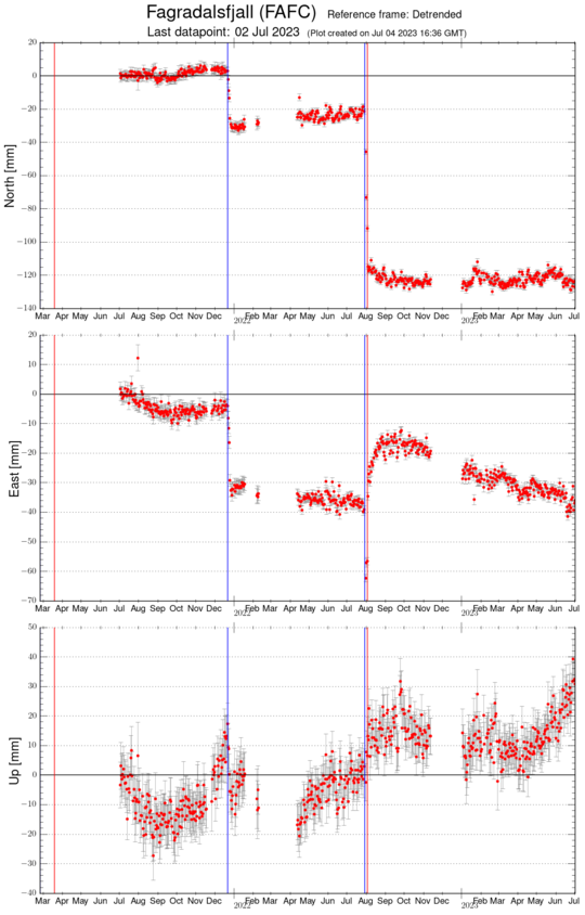
GPS time series of FAFC station located close to
inflation centre. The up component shows
an uplift starting in beginning of April 2023 and has currently reached around
3 cm.
Substantial seismic activity has been observed in the western part of the Reykjanes peninsula, with over 1000 earthquakes recorded in June 2023. The activity is focused mostly in an area from the SW tip of the peninsula to lake Kleifarvatn, with most of the activity occurring near the SW tip, NE of Fagradalsfjall and SW of lake Kleifarvatn. Since January 2023, the deep (> 8 km) seismicity around Fagradalsfjall is deeper and slightly more active than it was in late 2022.
Recent gas and temperature measurements show that the 2022 lava field continues to outgas, and it is still hot (> 219 °C) in places.
Further information about volcanic systems on Reykjanes Peninsula is available from the Catalogue of Icelandic Volcanoes.
Here are some more information on Reykjanes Peninsula on our website .
