HARMONIE - numerical weather prediction model
High resolution numerical weather prediction
Since autumn 2011 the Icelandic Meteorological Office (IMO) has been running the high resolution numerical weather prediction (NWP) model HARMONIE operationally. HARMONIE is a non-hydrostatic convection-permitting NWP and is operated at 2.5 km horizontal resolution over a domain that covers Iceland and the surrounding seas.
The development and maintainance of the model is a research cooperation of European meteorological institutes that was founded in 2005 when two research consortia joined forces. One of these consortium was the HIRLAM programme (High Resolution Limited Area Modelling). IMO has been a partner of the programme from the start in 1985, although not partaking in the development of the model until 1992. The HIRLAM consortium includes the meteorological institutes of all the Nordic countries as well as the Netherlands, Ireland, Lithuania and Spain.
The purpose of the consortium was originally to develop and maintain a numerical short-range weather forecasting system (forecast length 0-36 hours) for operational use by the participating meteorological institutes. The model initially developed was also named HIRLAM. IMO has used NWP products from HIRLAM run at the Danish Meteorological Office (DMI), initially at 15 km horizontal resolution and in the last years also at 5 km horizontal resolution.
In 2005 it was decided that the consortium should concentrate on the development of a high resolution NWP model and cooperate with MeteoFrance and the ALADIN consortium, lead by MeteoFrance. MeteoFrance had been developing the NWP AROME and it was decided that the two consortia, HIRLAM and ALADIN, would jointly develop that model further. The first version of the new model was released in 2008 and was given the name HARMONIE. Later this acronym was expanded into the long but somewhat cumbersome name HIRLAM ALADIN Research on Mesoscale Operational NWP In Euromed.
Weather prediction with HARMONIE
For NWP models to simulate weather they need to solve complicated equations involving the different factors that are important for the development of the state of the atmosphere. These factors are e.g. temperature, air pressure, winds, water vapour, clouds and precipitation as well as interactions at the surface of land and ocean. Processes involving these factors are the subject of physical and dynamical meteorology.
At the start (initial time) of a model simulation a description of the state of the atmosphere is needed. This state is termed the analysis. To ensure that the analysis includes all data important for the model as well as to ensure that the analysis is in agreement with the physics of the model the first guess is a short simulation by the model. Currently for the Iceland domain, measurements of temperature and humidity at 2 m a.g.l., in addition to other meteorological data, are then used to adjust this first guess of the analysis. This method of using both model simulation and observations to create a model analysis was originally suggested by Páll Bergþórsson, former director of IMO, and Bo R. Döös in 1955. In addition to the analysis, the model also needs prediction of the development of weather at the boundaries of the domain, retrieved from a coarser resolution global NWP simulation from the European Centre for Medium-Range Weather Forecasts (ECMWF).
HARMONIE is developed for horizontal resolution ranging from about 1 km to a few km. At IMO the horizontal resolution is 2.5 km. At this resolution it is possible to simulate explicitly some processes that are important for clouds and precipitation, e.g. the vertical movement of air parcels which improves simulations of updrafts and vertical velocity and thus enables the model to simulate larger convective clouds and convective precipitation (rain and snow showers). In addition, this enables the model to simulate better meteorological phenomena related to up- and downdrafts, e.g. in connection with sharp weather fronts, mountain waves and other impacts of orography on the atmospheric flow.
The interaction between the atmosphere and the surface
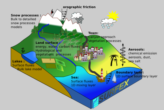
In order to be able to simulate the interaction between the atmosphere and the surface the model has to take into account different types of land surface and processes at and in the surface. HARMONIE includes, in addition to the atmospheric part, other models that simulate processes that influence the atmosphere. One of these models is SURFEX which simulates processes at the surface and in the soil, e.g. temperature and water balance, radiation balance and transfer of heat, see Figure 1. It is important to describe the surface, and its properties, as well as possible. To do this SURFEX uses elevation data (from the GTOPO3 database of USGS), data on sand- and clay fraction in soil (from the HWSD database of FAO) and data on land surface parameters (from the ECOCLIMAP-II).
The current set-up of HARMONIE at IMO
The current (autumn 2015) set up of HARMONIE is as follows:
- HARMONIE version 38h1.2
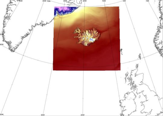
- Domain includes 500x480 horizontal grid points, horizontal resolution 2.5 km, see Figure 2.
- 65 layers in the vertical, top layer at 10 hPa (~30 km a.g.l.)
- Simulations are performed four times a day
- Forecasts length 66 hours, time interval of output 1 hour
More information on HARMONIE can be found in Seity et al. 2011 and on the HARMONIE web site.


