The Bárdarbunga/Holuhraun eruption 2014-2015
The Bárdarbunga/Holuhraun eruption 2014-2015
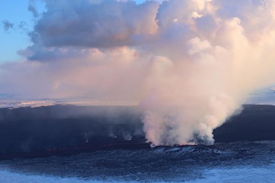
An eruption lasting for 6 months occurred 2014-2015 in Holuhraun lavafield, north of Vatnajökull, on the Bárdarbunga volcanic system. The eruption started 29 August 2014 and effusive activity continued until 27 February 2015. The Vatnajökull glacier covers both central volcanoes and in total ~33% of the volcanic system. Bárðarbunga is the most extensive volcanic system in Iceland, reaching 190 km from the southernmost point to the northernmost. It is the second most active volcanic system in the country with 26 known eruptions during the last 1100 years. Most eruptions are explosive basaltic eruptions but large effusive eruptions are known, such as the Þjórsárhraun that was formed ~8600 years ago and flowed 130 km following river channels.

Holuhraun, October 2014. Photo: Morten S. Riishuus.
For more information on the Bárðarbunga volcanic system, visit Catalogue of Icelandic volcanoes .
Bárðarbunga and Holuhraun - an overview and links
An overview of the Bárðarbunga seismic events and the Holuhraun eruption, 2014-2015, is given here with notes, factsheets and observations. New material was added to the top of each monthly article. Combined, the monthly articles give an overview of events, see: August, September, October, November, December, January, February, March-April-May and this overview.
Links to all relevant articles on IMO's web
Natural Hazards Banner
Update Bárðarbunga 2014 - August events (download as pdf 1,14 Mb)
Update Bárðarbunga 2014 - September events (download as pdf 2,22 Mb)
Update Bárðarbunga 2014 - October events (download as pdf 1,09 Mb)
Update Bárðarbunga 2014 - November events (download as pdf 0,89 Mb)
Update Bárðarbunga 2014 - December events (download as pdf 0,84 Mb)
Update Bárðarbunga 2015 - January events (download as pdf 0.92 Mb)
Update Bárðarbunga 2015 - February events (download as pdf 1.28 Mb)
Update Bárðarbunga 2015 - March-April-May follow up (see pdf 0.71 Mb)
Earthquakes Bárðarbunga - all earthquakes
Earthquakes Bárðarbunga earthquakes - 3D video
Earthquakes Bárðarbunga earthquakes - 3D interactive model
GPS map Bárðarbunga GPS displacements
Subsidence Vertical displacement in the Bárðarbunga caldera
Gas observ. Volcanic gas detected
Gas observ. I want to report
Gas observ. View public observations
Gas observ. Handheld meters results
Gas observ. Hazard zoning
Gas forecast Text and maps approved by meteorologist on duty
Gas model Gas dispersion model
Prohibited area Prohibited area around the Holuhraun lava field
Prohibited area Preliminary assessment of the risk of flooding
Short articles on the subject
The latest articles are on top of the list:
Steam plumes from Holuhraun lava field
Bárðarbunga - decay of seismic activity
Photos of the ice cauldrons at Bárðarbunga
Gradual fading of seismic activity at Bárðarbunga and the dyke intrusion
100 days of gas release at Holuhraun
Flight over NW-Vatnajökull 24 Oct 2014
Photos from field trips (text in Icelandic)
The low frequency tremor 23rd August 2014
A chapter on Bárðarbunga
Bárðarbunga system, a pre-publication extract from the Catalogue of Icelandic Volcanoes (pdf 0.9 Mb).
News
In reversed order.2016
On the Bárðarbunga gradual caldera collapse - An article in Science
Activity in the Bárðarbunga system since the end of the eruption
2015
The eruption has come to an end
Monitoring device rescued from the lava
2014
The segmented dyke intrusion explained
What is Bárðarbunga? - including a chapter from the Catalogue of Icelandic Volanoes (in progress)
The FutureVolc project and the eruption on National Geographic
Hard work in harsh circumstances
A reconnaissance flight with TF-SIF
Updated summary from Bárðarbunga
Summary of activity in Bárðarbunga
Seismic activity at Bárðarbunga persists
Activity in Bárðarbunga volcano
Earthquake swarm by Bárðarbunga volcano


