Instructions on using wind, precipitation and temperature forecasts
Keep the following points in mind:
- Wind, precipitation and temperature (weather element) forecasts are automatic forecasts, created using a computer model.
- Read the text forecasts instead of relying solely on the automatic, map-based forecasts.
- If a large discrepancy exists between the automatic forecast and the text forecast, then the text forecast applies.
- Keep in mind that short-term forecasts are more likely to be accurate than long-term forecasts.
- By clicking the left or right arrow key on your keyboard, it is possible to change the time-span of the forecast. Similarly, the weather-element forecasts can be browsed by pressing the numeric keys one to four on your keyboard.
Forecast types:
- Each component of the weather-element forecast can be viewed by pressing the numeric keys one to four on your keyboard.
- The weather element forecasts displayed on the maps are wind, precipitation and temperature, in addition to a combined forecast containing all three elements.
Temperature forecasts:
-
The map displays the temperature distribution for the country in degrees Celsius (°C) at an altitude of 2 m.
-
The colours represent 2°C temperature intervals.
-
The temperature scale on the image changes according to the temperature range of the forecast.
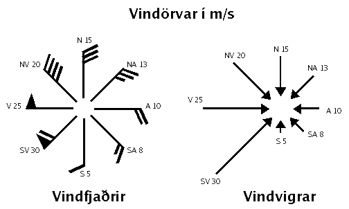
Wind forecasts:
-
The map displays wind direction and wind speed (in m/s) based on 10-minute averages.
-
Wind direction is denoted by arrows.
-
The wind-speed scale on the image changes in relation to the forecast speed.
-
The lowest wind-speed interval, 0-2 m/s, is yellow; when the speed exceeds 22 m/s the colour turns purple, and when the wind exceeds 28 m/s red colouring is used.
-
Wind direction and wind speed are displayed as a combined vector. The direction of the arrow is indicative of wind direction, and the length of the arrow signifies the strength of the wind.
Precipitation forecasts:
- The forecast map displays cumulative levels of precipitation over a 1-hour, 3-hour or 6-hour period, depending on the forecast length.
- The colour scale denotes precipitation rates, from light precipitation of 0.1 mm/hour (0.3 mm/3 hours and 0.5 mm/6 hours) shown in light yellow, up to heavy precipitation of 50 mm/hour (90 mm/3 hours and 200 mm/6 hours) shown in red.
- Wind barbs are also shown on the maps. The stem of the barb shows the direction of the wind, which blows toward the point of the barb. Wind-speed is symbolized by diagonal lines at the end of the barb; for instance, a short line represents 2.5 m/s, a long line 5 m/s and a triangle represents 25 m/s.
- Mean sea level pressure is shown in solid lines, the contour interval is 2 hPa.
The sliding bar below the map is used to change the validity time of the forecast
It is possible to change the validity time in many ways:
- It is possible to click anywhere on the bar.
- It is possible to click on the days above the bar to view the noon forecast for a specific day.
- It is possible to click on the time below the bar.
- It is possible to click on the arrows on either side of the bar to view the previous or the next validity time.